Rennsteig - Stage 6 - Steinbach am Wald – Blankenstein (Saale)
Trail records – Stage 6:
Hiking Trail: Rennsteig
Stage: 6. Steinbach am Wald – Blankenstein (Saale)
Continent: Europe
Region: Central Europe
Countries: Germany
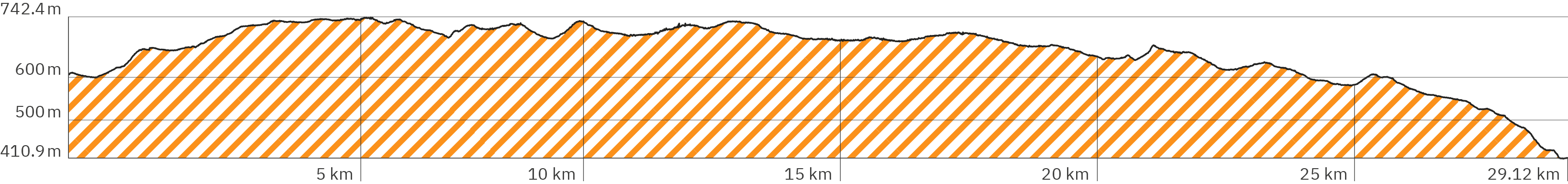
Length: approx. 29.1 km
Altitude: approx. 411m – 742m
Duration: approx. 9.5 Std.
Peak travel season: May to September
Start: Steinbach am Wald
End: Selbitzbrücke in Blankenstein (Saale)
Pano tour photos: Sep. & Oct. 2011
Ad

Elevation curve – Stage 6:
Interactive Panoramic Tour:
Legend – 360° Panoramic Tour

Main path forward

Main path backward

Detour forward

Detour backward

Explore forward

Explore backward
Legend – Map
Waypoint
Start / End
Detour
Explore
Point with extra info
Rest
Path type
Turnoff
Shelter
Accommodation
Camping
Public transport
Supermarket
View
Lavatory
Drinking water
ATM
Parking
Attention
Activity
Snack bar / Restaurant
I walked the 6th and last stage almost entirely in the rain. That’s why the quality of the pictures in the pano-tour is sometimes very low, since my mirror attachment was becoming more and more smeared and scratched. Unfortunately, I had to skip a section (around the end of the second third) due to very heavy rain.
On stage 6, the Rennsteig meanders along the Bavarian-Thuringian border at the beginning. The final stage is just a bit shorter than stage 5, but overall more downhill (ratio of 474m climb to 669m descent).
Level of difficulty:
Easy to hard – due to the length of the stage (almost like the first stage), physically challenging and very demanding.
Provisions:
On the way there is only one snack bar directly on the way and very few shelters – and the restaurants do not seem to be open permanently. Therefore, enough provisions and water must be carried along from the start.
Snack bars, restaurants & shops:
Supermarket – around km 0.8 (Google link also in pano)
Restaurant Mareile am Rennsteig – around km 14.4 – nur an ausgewählten Tagen geöffnet (Google link also in pano), guesthouse currently closed, website mareile-am-rennsteig.de
At the end of the stage in Blankenstein (Saale):
Restaurant Gasthaus & Pension Rennsteig – around km 29.0 (Google link also in pano), website gasthaus-rennsteig.de
Restaurant Wanderstützpunkt – Gaststätte & Touristeninformation – around km 29.0 (Google link also in pano), website blankenstein-am-rennsteig.de
Shelters:
According to my research, there is no shelter listed in Google Maps for the last stage. And there are only very few:
Shelter on the old border strip between East- and West-Germany – around km 5.7, outdoor table and benches with backrests
Shelter – around km 6.3
Shelter – around km 10.0, rustic, small, round with the shape of a tipi
Shelter – around km 14.6
Worth seeing:
Only at the end of the stage and thus the end of the Rennsteig: the beautiful wooden bridge Selbitzbrücke (Google link also in pano) with idyllic view on the Selbitz (confluent of the river Saale).
Public transport:
Bus stop Brennersgrün – around km 8.2 (Google link also in pano). bus 610, public transport website kombus-online.eu
Train station Blankenstein (Saale) – around km 28.9 (Google link also in pano), train RB32, public transport website erfurter-bahn.de
Accommodation at the start of the stage in Steinbach am Wald:
Rennsteighotel (Google link also in pano), website hotelrennsteig.de
Accommodation along the trail:
Rennsteighaus Brennersgrün – around km 8.2 (Google link also in pano), website rennsteig.de/rennsteighaus-brennersgruen
Currently closed: Mareile am Rennsteige – around km 14.4 – restaurant only open on specific days (Google link also in pano), website mareile-am-rennsteig.de
Accommodation at the end of the stage in Blankenstein:
Gasthaus & Pension Rennsteig – around km 29.0 (Google link also in pano), website gasthaus-rennsteig.de
Rennsteig – Stage 6 – Pano rse-228
> Start of the 6th stage in the small town Steinbach am Wald
> Accommodation Rennsteighotel (Google link also in pano), website hotelrennsteig.de (closest guesthouse to the trail), alternative Accommodation in Steinbach am Wald (Booking.com link)*
> Blue arrow for rear view / entrance
> Link to the previous 5th stage in pano
Rennsteig – Stage 6 – Panorama rse-229
> Hotel & restaurant entrance
Rennsteig – Stage 6 – Pano rsf-1
> Slightly downhill on pavement of the main road
Rennsteig – Stage 6 – Pano rsf-2
> Continue straight ahead
Rennsteig – Stage 6 – Pano rsf-3
> Continue straight ahead, slightly uphill
Rennsteig – Stage 6 – Pano rsf-4
> Change the side of the road to use the sidewalk – continue straight at the next roundabout
> Around here should be the new supermarket location (Google link also in pano)
Rennsteig – Stage 6 – Pano rsf-5
> Table and benches under small roof
> Turn semi left into the meadow path
> Slightly uphill on a rougher path
Rennsteig – Stage 6 – Pano rsf-6
> Steep uphill, soft forest path criss-crossed with roots
Rennsteig – Stage 6 – Pano rsf-9
> Bench with backrest
> Semi left on the paved sidewalk
> Slightly downhill along the country road
Rennsteig – Stage 6 – Pano rsf-10
> Continue on the paved path, which leaves the main road for a short time, slightly uphill
Rennsteig – Stage 6 – Pano rsf-11
> Continue straight ahead, stay left alongside the road
> Slightly stronger downhill
Rennsteig – Stage 6 – Pano rsf-12
> After the roundabout (continue straight ahead) slightly uphill
Rennsteig – Stage 6 – Pano rsf-13
> Small parking lot with rubbish bin
> Turn sharp right into the forest
> Stronger uphill on a wide dirt road
Rennsteig – Stage 6 – Pano rsf-14
> Continue straight ahead on drivable gravel road
> Steep uphill, then longer straight ahead slightly downhill
Rennsteig – Stage 6 – Pano rsf-16
> Small bench
> Turn left at the fork
> Steeper uphill
Rennsteig – Stage 6 – Pano rsf-17
> The path runs about 1 km along the former German-German border
> It gets flatter
Rennsteig – Stage 6 – Pano rsf-19
> Turn semi left onto a narrow path
> Softer with tall grass
Rennsteig – Stage 6 – Pano rsf-21
> Stronger uphill, uneven forest path
> Partly muddy, interspersed with roots
Rennsteig – Stage 6 – Pano rsf-23
> Continue straight ahead on meadow path
> Flatter, rockier, with short ups and downs
Rennsteig – Stage 6 – Pano rsf-25
> Road makes sharp left turn
Rennsteig – Stage 6 – Pano rsf-26
> Shelter on the old border strip
> Table and benches with backrest
> Continue straight ahead (left of the hut)
> Slightly uphill, soft forest path with roots
Rennsteig – Stage 6 – Pano rsf-29
> Turn right
Rennsteig – Stage 6 – Pano rsf-30
> Turn right on wide, drivable gravel road
Rennsteig – Stage 6 – Pano rsf-32
> Shelter
> Turn semi right onto narrow forest path
> Slightly downhill
Rennsteig – Stage 6 – Pano rsf-35
> Continue straight ahead
Rennsteig – Stage 6 – Pano rsf-37
> Continue straight ahead on forest path
> Steeper uphill
Rennsteig – Stage 6 – Pano rsf-39
> Stronger downhill
Rennsteig – Stage 6 – Pano rsf-40
> Stronger uphill
Rennsteig – Stage 6 – Pano rsf-41
> Continue straight towards the entrance to Brennersgrün
Rennsteig – Stage 6 – Pano rsf-42
> Table and benches under a small roof
> Slightly downhill through the village on the main road
Rennsteig – Stage 6 – Pano rsf-43
> Accommodation Rennsteighaus Brennersgrün (Google link also in pano), website rennsteig.de/rennsteighaus-brennersgruen
> Bus stop Brennersgrün (Google link also in pano), bus 610 – public transport website kombus-online.eu
> Stronger uphill on asphalt
Rennsteig – Stage 6 – Pano rsf-44
> Tables and benches under small roof
> Continue on grass left along the road
Rennsteig – Stage 6 – Pano rsf-45
> Bench with backrest
> Turn semi left onto a soft uneven forest path, slightly uphill
Rennsteig – Stage 6 – Pano rsf-48
> Turn sharp left onto wide, drivable gravel road
> The hike leads through Bavaria
Rennsteig – Stage 6 – Pano rsf-49
> Longer slightly downhill
Rennsteig – Stage 6 – Pano rsf-51
> Continue straight ahead on narrow forest path
Rennsteig – Stage 6 – Pano rsf-52
> Keep left, steeper uphill
> Very soft forest path, loamy with roots
Rennsteig – Stage 6 – Pano rsf-54
> Continue straight ahead on forest path
Rennsteig – Stage 6 – Pano rsf-56
> Continue straight ahead, a bit flatter
Rennsteig – Stage 6 – Pano rsf-57
> Rustic round shelter in the shape of a tipi, less space
> Continue straight ahead on forest path, more downhill
> Back in Thuringia
Rennsteig – Stage 6 – Pano rsf-60
> Turn Semi right, on wide slightly overgrown path, flatter
Rennsteig – Stage 6 – Pano rsf-61
> Turn left, continue on wide drivable gravel road
Rennsteig – Stage 6 – Pano rsf-62
> Continue straight ahead
Rennsteig – Stage 6 – Pano rsf-63
> Cross the street, continue straight ahead
Rennsteig – Stage 6 – Pano rsf-65
> Continue halfway to the right
> Overgrown path across an open field
Rennsteig – Stage 6 – Pano rsf-68
> Cross the street, continue straight ahead
Rennsteig – Stage 6 – Pano rsf-69
> Table and benches under a small roof
> Soft forest path with roots, more uphill
Rennsteig – Stage 6 – Pano rsf-71
> Narrow path, a bit rocky, slightly downhill
Rennsteig – Stage 6 – Pano rsf-72
> Path becomes softer again with roots, slightly uphill
Rennsteig – Stage 6 – Pano rsf-74
> Continue straight ahead on uneven path
Rennsteig – Stage 6 – Pano rsf-75
> Semi right, cross wide forest path, continue on soft forest path
Rennsteig – Stage 6 – Pano rsf-76
> Semi left, cross wide forest path, continue on uneven forest path with roots, steeper downhill
Rennsteig – Stage 6 – Pano rsf-78
> Narrower, firmer with stones, slightly downhill
Rennsteig – Stage 6 – Pano rsf-79
> Continue straight ahead on drivable gravel road
Rennsteig – Stage 6 – Pano rsf-81
> Continue straight ahead
Rennsteig – Stage 6 – Pano rsf-82
> Turn left, continue on grass/sand along the road
Rennsteig – Stage 6 – Pano rsf-83
> Snack bar Mareile am Rennsteige – only open on selected days (Google link also in pano), accommodation currently closed, website mareile-am-rennsteig.de
Rennsteig – Stage 6 – Pano rsf-84
> Shelter
> Left of the country road, turn semi left into narrow forest path, slightly downhill
Rennsteig – Stage 6 – Pano rsf-85
> Turn right, cross the country road
Rennsteig – Stage 6 – Pano rsf-86
> Semi left into forest path, slightly uphill
> Soft, uneven and full of roots
Rennsteig – Stage 6 – Pano rsf-87
> Continue straight ahead, more uphill
Rennsteig – Stage 6 – Pano rsf-88
> Flat to slightly downhill
Rennsteig – Stage 6 – Pano rsf-89
> Semit left on wide level gravel path, slightly uphill
Rennsteig – Stage 6 – Pano rsf-90
> Slightly downhill
Rennsteig – Stage 6 – Pano rsf-92
> Continue straight ahead
Rennsteig – Stage 6 – Pano rsf-93
> Continue straight ahead, slightly uphill
> Due to heavy rain, approx. 4.3 km no photos / detailed description, approx. at km 19.1 sharp right (to the south) then in a long south-east semicircle around a gravel pit, then at approx. km 21.1 sharp right (east) to the village Schlegel (Rosenthal am Rennsteig) – see the map above for the route
Rennsteig – Stage 6 – Pano rsf-94
> Re-entry (after 4.3 km) of the pano tour / detailed description – interruption of the documentation due to heavy rain
> Table and benches with backrest
> Slightly downhill on a field path overgrown with grass
Rennsteig – Stage 6 – Pano rsf-95
> Cross the country road semi left
Rennsteig – Stage 6 – Pano rsf-96
> Slightly uphill, overgrown field path
Rennsteig – Stage 6 – Pano rsf-97
> Bench with backrest and view over the field
> Slightly downhill
Rennsteig – Stage 6 – Pano rsf-99
> Table and benches with backrest
Rennsteig – Stage 6 – Pano rsf-100
> Slightly stronger downhill
Rennsteig – Stage 6 – Pano rsf-101
> Table and benches with backrest
Rennsteig – Stage 6 – Pano rsf-102
> Semi left on asphalt in the village, slightly downhill
> Caution: no sidewalk next to the road
Rennsteig – Stage 6 – Pano rsf-103
> Turn semi right, slightly uphill
Rennsteig – Stage 6 – Pano rsf-104
> Continue straight ahead (keep slightly to the right)
Rennsteig – Stage 6 – Pano rsf-105
> Follow the course of the road to the left
Rennsteig – Stage 6 – Pano rsf-106
> Semi left on a path overgrown with grass
Rennsteig – Stage 6 – Pano rsf-107
> Continue straight ahead, more uphill
Rennsteig – Stage 6 – Pano rsf-108
> Table and benches with a small canopy
> Continue on overgrown dirt road, slightly downhill
Rennsteig – Stage 6 – Pano rsf-109
> Continue straight ahead, more uphill
Rennsteig – Stage 6 – Pano rsf-110
> Bench with backrest and view over the field
> Rather flat
Rennsteig – Stage 6 – Pano rsf-111
> Continue on grass path right along the country road, more downhill
Rennsteig – Stage 6 – Pano rsf-113
> Table and benches with backrest
Rennsteig – Stage 6 – Pano rsf-115
> Continue straight ahead (right along the country road)
Rennsteig – Stage 6 – Pano rsf-117
> Slightly downhill
Rennsteig – Stage 6 – Pano rsf-118
> Parking lot Rastplatz Wegespinne (Google link also in pano)
> Tables and benches
Rennsteig – Stage 6 – Pano rsf-119
> Continue straight ahead, right of the country road
> Narrow gravel path on grass, more downhill
Rennsteig – Stage 6 – Pano rsf-120
> Straight ahead, slightly uphill
Rennsteig – Stage 6 – Pano rsf-121
> Semi right (2 meters steeply up)
Rennsteig – Stage 6 – Pano rsf-122
> Directly left, continue on a passable path, slightly uphill
> Short section not directly next the road
Rennsteig – Stage 6 – Pano rsf-124
> Tables and benches under small roof
Rennsteig – Stage 6 – Pano rsf-125
> Continue straight ahead, dirt field path right along the road
Rennsteig – Stage 6 – Pano rsf-126
> Small round plate with local distances
> More downhill
Rennsteig – Stage 6 – Pano rsf-127
> Continue straight ahead, slightly downhill
Rennsteig – Stage 6 – Pano rsf-129
> Narrowing forces you to change road sides
Rennsteig – Stage 6 – Pano rsf-130
> Keep right
> Narrowing forces you to change road sides
> Partly on asphalt
Rennsteig – Stage 6 – Pano rsf-131
> Continue on the left side of the road
Rennsteig – Stage 6 – Pano rsf-132
> Narrow field path with gravel alongside the road, slightly uphill
Rennsteig – Stage 6 – Pano rsf-135
> Tables and benches with backrest (without shade)
> More downhill
Rennsteig – Stage 6 – Pano rsf-136
> Continue straight on overgrown narrow footpath along the road
Rennsteig – Stage 6 – Pano rsf-137
> Turn right onto the dirt road, rather flat
Rennsteig – Stage 6 – Pano rsf-138
> Follow the dirt road that bends to the left, slightly downhill
Rennsteig – Stage 6 – Pano rsf-139
> Turn left
Rennsteig – Stage 6 – Pano rsf-140
> Turn right, continue right along the country road on a trail, more downhill
Rennsteig – Stage 6 – Pano rsf-141
> Bench with stone wall as backrest under trees
> Turn left onto the gravel road
Rennsteig – Stage 6 – Pano rsf-144
> Public old tap with drinking water
> Continue straight ahead on gravel, slightly downhill
Rennsteig – Stage 6 – Pano rsf-145
> Continue straight ahead (keep right)
Rennsteig – Stage 6 – Pano rsf-146
> Cross the street, continue straight ahead, steeper downhill
Rennsteig – Stage 6 – Pano rsf-147
> Continue straight ahead, more downhill on asphalt
Rennsteig – Stage 6 – Pano rsf-149
> Train station Blankenstein (Saale) (Google link also in pano), train RB32, public transport website erfurter-bahn.de
> Turn semi left
Rennsteig – Stage 6 – Pano rsf-150
> Flat on pavement along the tracks
Rennsteig – Stage 6 – Pano rsf-151
> Restaurant & accommodation Gasthaus & Pension Rennsteig (Google link also in pano), website gasthaus-rennsteig.de
> Turn sharp right, cross train tracks, back on the other side, steeper downhill
Rennsteig – Stage 6 – Pano rsf-152
> Restaurant & tourist information Wanderstützpunkt – Gaststätte & Touristeninformation (Google link also in pano), website blankenstein-am-rennsteig.de
> Turn left (cross the street) between the houses, slightly downhill
Rennsteig – Stage 6 – Pano rsf-153
> Turn right, continue flat on asphalt road
> Large public parking
Rennsteig – Stage 6 – Pano rsf-154
> Information boards for the Rennsteig
> Semi left, slightly uphill towards the bridge
Rennsteig – Stage 6 – Pano rsf-155
> Tables and benches with backrest (without shade)
> Rennsteig info board on the, typical Rennsteig signpost hung with disused hiking boots
> Turn left on a paved path up to the bridge
Rennsteig – Stage 6 – Pano rsf-156
> What a beautiful finish: the wooden bridge Selbitzbrücke (Google link also in pano), the end of the Rennsteig – respectively the start depending on which way you walk the trail
Rennsteig – Stage 6 – Pano rsf-157
> End of the 6th stage, thus the Rennsteig end/start (Google link also in pano)
> Nice view on the Selbitz (confluence of the river Saale)
> A few meters further down you reach the „Drehkreuz des Wanderns“ („Turnstile of hiking“ – Google link also in pano), website wandern-im-frankenwald.de
> Link to the HikingTriailView.com Rennsteig starting page also in pano
Ad