Rennsteig - Stage 1 - Hörschel – Inselsberg
Trail records – Stage 1:
Hiking Trail: Rennsteig
Stage: 1. Hörschel – Inselsberg
Continent: Europe
Region: Central Europe
Countries: Germany
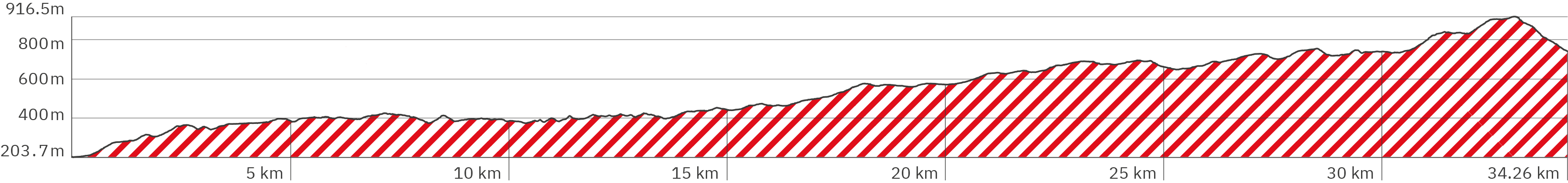
Length: approx. 34.2 km
Altitude: approx. 204 m to 916 m
Duration: approx. 12 hrs.
Peak travel season: May to September
Start: Hörschel
End: Großer Inselsberg
Pano tour photos: Sep. & Oct. 2011
Ad

Elevation curve – Stage 1:
Interactive Panoramic Tour:
Legend – 360° Panoramic Tour

Main path forward

Main path backward

Detour forward

Detour backward

Explore forward

Explore backward
Legend – Map
Waypoint
Start / End
Detour
Explore
Point with extra info
Rest
Path type
Turnoff
Shelter
Accommodation
Camping
Public transport
Supermarket
View
Lavatory
Drinking water
ATM
Parking
Attention
Activity
Snack bar / Restaurant
The first Rennsteig stage starts in Hörschel at the river Werra, right behind the guesthouse „Tor zum Rennsteig“ (booking.com link)*. The first stage leads from Hörschel up to the „Großer Inselsberg“. After a lot of hiking in the forest, you will be rewarded with a wonderful, wide view over the country. The hike begins steeply, then levels off a bit with an alternation of short ascents and descents and becomes particularly steep towards the end. The trail alternates between flat gravel paths and earthy forest paths criss-crossed by roots – often as a hiking alternative alongside the gravel paths (which are more used by cyclists). If you want to stay overnight on top of the Großer Inselsberg, you should book early. Otherwise you have to descend the Inselsberg on the other side for about 30 minutes and use alternative hotels, such as Hotel Kleiner Inselsberg (link to booking.com)*. I stayed over in the guesthouse Pension Rose am Reitstein (link to Google Maps) (hotel website https://haus-am-reitstein.de).
Level of difficulty:
Medium to hard – due to the length of the stage (it is the longest of the Rennsteig stages), physically very challenging and very demanding, especially if you need to add the extra 1-2 downhill kilometers to reach your accommodation at the foot of Großer Inselsberg.
Provisions:
On the way, various snack bars invite you to take a break. In order not to stand in front of closed doors, you should check whether they are open in advance. Basically, you should always have some food and, above all, enough water with you, as the Rennsteig stages are very long.
Snack bars & restaurants:
Grill Hohe Sonne – around km 14 (link to Google Maps)
Waldgasthof Hubertushaus – around km 19 (link to Google Maps)
Imbiss zu Wallfahrt am Rennsteig – around km 25 (link to Google Maps)
Waldschänke Dreiherrnstein – around km 28 (link to Google Maps)
(guesthouse link) https://gasthausrennsteig.de)
Berggasthof Stöhr – around km 33 at the stage’s end (link to Google Maps)
Shelters:
Hardened hikers spend the night in the open shelters. Important: They are open, without doors and without a toilet. They are marked with the shelter icon in the map of the panorama tour. Three of them also have their own entry in Google Maps – although the „Schutzhütte der Extraklasse“ („extraordinary shelter“) did not exist at the time of my hike.
Ruhlaer Häuschen – around km 21 (link to Google Maps)
Große Meilerstätte – around km 23 (link to Google Maps)
Schutzhütte der Extraklasse – around km 24 (link to Google Maps)
Accommodation at the stage’s start:
Pension „Tor zum Rennsteig“ (booking.com link)*
Accommodation at the stage’s end:
Options at the top of Großer Inselsberg:
Berggasthof Stöhr – at the end of the stage, around km 33 (link to Google Maps), website berggasthof-stoehr.de
Herberge Großer Inselsberg (link to Google Maps), website herberge-inselsberg.de
Alternative accommodation with an extra descent of the „Großer Inselsberg“ of roughly 30 minutes:
Hotel Kleiner Inselsberg (booking.com link)*
Pension Rose am Reitstein (Google link) Website: haus-am-reitstein.de
Public transport / Getting there:
For the start you can take the train RB6 (public transport websites bahn.de & cantus-bahn.de) to the station Hörschel (link to Google Maps) – or park your car in a bigger parking lot near by (link to Google Maps).
At the end of the stage you can park your car at the Parkplatz Großer Inselsberg. Further down, at the foot of the mountain, you find the the bus stop Kleiner Inselsberg (link to Google Maps) for the buses 142 & 857 (link to the public transport website vg-wartburgregion.de) connecting the city of Eisenach and the village Bad Tabarz. The parking space down there seems to be private and cost a fee.
Rennsteig – Stage 1 – Pano rsa-5
> Start – directly at the river Werra
> Custom: Take a stone with you, which you throw into the Saale at the end of the Rennsteig
> Roofed benches and tables invite you to have a picnic
> Turn pano 180° to see green arrow to click to next pano
Rennsteig – Stage 1 – Pano rsa-6
> A typical Rennsteig signpost: a fork in a branch, but also embellished by hikers with worn-out hiking boots
> The path begins with a level gravel path
Rennsteig – Stage 1 – Pano rsa-4 (numbering inserted)
> Accommodation: Guesthouse „Tor zum Rennsteig“ (link to Booking.com)* (turn 180° to see the entrance)
Rennsteig – Stage 1 – Pano rsa-8
> Keep right after the church
> Possibility to rest on a bench
Rennsteig – Stage 1 – Pano rsa-9
> Cross the street and turn left onto the path
Rennsteig – Stage 1 – Pano rsa-10
> Slightly uphill gravel path
Rennsteig – Stage 1 – Pano rsa-11
> Keep right at the fork in the road
> Slightly uphill, uneven dirt road
Rennsteig – Stage 1 – Pano rsa-14
> Dirt road becomes more uneven with larger stones in the loamy soil – further uphill
Rennsteig – Stage 1 – Pano rsa-16
> Possibility to rest on a bench
> Only narrow sidewalks on the sides of the dirt road
Rennsteig – Stage 1 – Pano rsa-18
> keep right
Rennsteig – Stage 1 – Pano rsa-19
> The ascent becomes steeper
Rennsteig – Stage 1 – Pano rsa-20
> The path leaves the forest and leads slightly uphill, very uneven and narrow tractor path across an open field without sun protection
Rennsteig – Stage 1 – Pano rsa-21
> Possible shelter in a small, open hut with no windows and no door
> Rest area with table and bench
> It goes slightly downhill
Rennsteig – Stage 1 – Pano rsa-22
> Turn right
> Trail is a little smoother and more level
Rennsteig – Stage 1 – Pano rsa-23
> Continue straight ahead
Rennsteig – Stage 1 – Pano rsa-24
> Continue to the right on the more frequently used dirt road
> The path leads uphill again on gravel into the forest; it’s getting cooler
Rennsteig – Stage 1 – Pano rsa-27
> Possibility to rest on a bench
Rennsteig – Stage 1 – Pano rsa-30
> The path becomes more uneven but flatter
Rennsteig – Stage 1 – Pano rsa-33
> Possibility to rest on a small bench at a typical Rennsteig signpost
> The path bends to the right
Rennsteig – Stage 1 – Pano rsa-38
> Refuge interior view: mostly without windows with open passages – not sure if the roofs are tight
Rennsteig – Stage 1 – Pano rsa-39
> Possible shelter in an open hut, turn left in the pano and take a look inside!
> Rest area with table and benches
Rennsteig – Stage 1 – Pano rsa-40
> Steep forest path, with uneven lane grooves
Rennsteig – Stage 1 – Pano rsa-42
> Hardly any incline
Rennsteig – Stage 1 – Pano rsa-43
> Turn right, steeper uphill
Rennsteig – Stage 1 – Pano rsa-44
> Steeper uphill, on a narrow, earthy path, very uneven over stones and roots
Rennsteig – Stage 1 – Pano rsa-45
> Bench to rest with a view over an open field
Rennsteig – Stage 1 – Pano rsa-49
> Turn right
> Continue on a level forest path (gravel)
Rennsteig – Stage 1 – Pano rsa-50
> Turn right
> Back on a dirt forest path, uneven with lots of roots
Rennsteig – Stage 1 – Pano rsa-51
> Turn left
> Continue on a developed gravel path, flat, partly slightly downhill and level
Rennsteig – Stage 1 – Pano rsa-52
> Roofed rest area with table and benches in the shade of the forest
Rennsteig – Stage 1 – Pano rsa-53
> Turn left
Rennsteig – Stage 1 – Pano rsa-55
> Continue straight ahead
Rennsteig – Stage 1 – Pano rsa-56
> Possibility to rest in the shade on a small bench without a backrest
Rennsteig – Stage 1 – Pano rsa-58
> Possibility to rest in the shade on a bench with a backrest and a view over a field
Rennsteig – Stage 1 – Pano rsa-59
> Continue straight ahead
Rennsteig – Stage 1 – Pano rsa-60
> Follow the road to the right
> The path continues uphill on a paved road
Rennsteig – Stage 1 – Pano rsa-64
> Alternative to the road: along the left, follow the narrow softer path through taller grass
Rennsteig – Stage 1 – Pano rsa-66
> Seat without backrest
> The path leads slightly up and down on an uneven, narrow forest path criss-crossed with roots along the country road
Rennsteig – Stage 1 – Pano rsa-72
> Continue straight ahead, cross the forest path
Rennsteig – Stage 1 – Pano rsa-73
> Turn semi right, cross the country road
> Beware of approaching cars, the crossing is in a curve!
> It goes downhill on long, flat steps
Rennsteig – Stage 1 – Pano rsa-74
> Bus stop „Vachaer Stein“ (link to Google Maps also inside the pano), buses also to the city of Eisenach, infos at public transport website vg-wartburgregion.de
> Be careful when crossing the expressway
> Cross the street and turn right
> For a short time flat on asphalt
Rennsteig – Stage 1 – Pano rsa-75
> Pass the car park on the left and then turn left into the forest path
> Slightly uphill on a level gravel path
Rennsteig – Stage 1 – Pano rsa-77
> Continue to the right on the forest path with tall grass on a narrow dirt path steeper uphill
Rennsteig – Stage 1 – Pano rsa-79
> Possibility to rest at a table on a bench with and one without backrest
Rennsteig – Stage 1 – Pano rsa-80
> Continue slightly downhill
Rennsteig – Stage 1 – Pano rsa-82
> Turn right but keep left immediately
> Continue on the level, passable gravel road
Rennsteig – Stage 1 – Pano rsa-84
> Right again on the earthy, narrow forest path
> It goes steeper uphill
Rennsteig – Stage 1 – Pano rsa-88
> keep to the right and immediately to the left
> Flat and level continue on the trafficable gravel road
Rennsteig – Stage 1 – Pano rsa-89
> Possibility to rest on two benches with backrest and table in the middle
Rennsteig – Stage 1 – Pano rsa-93
> Larger roof with tables and benches for rest
> Continue straight ahead
Rennsteig – Stage 1 – Pano rsa-97
> Continue left on the earthy, narrow forest path, steeper uphill over roots
Rennsteig – Stage 1 – Pano rsa-98
> The path becomes wider and more firm with occasional loose and sharp stones
Rennsteig – Stage 1 – Pano rsa-99
> The path becomes overgrown again and continues flatter on narrow paths
Rennsteig – Stage 1 – Pano rsa-100
> Possibility to rest on benches without backrests with a table in the middle
Rennsteig – Stage 1 – Pano rsa-104
> Continue straight ahead
Rennsteig – Stage 1 – Pano rsa-105
> Turn right
> Continue on the trafficable, level gravel road
Rennsteig – Stage 1 – Pano rsa-106
> Follow the path to the left of the bench
> Possibility to rest on a bench with a backrest
> Continue on a narrow, earthy forest path, steeper uphill
Rennsteig – Stage 1 – Pano rsa-108
> shelter
> Possibility to rest at the table on benches with backrests
> Turn sharp right
Rennsteig – Stage 1 – Pano rsa-109
> Continue to the left
Rennsteig – Stage 1 – Pano rsa-110
> Continue straight ahead
Rennsteig – Stage 1 – Pano rsa-111
> Continue straight ahead
Rennsteig – Stage 1 – Pano rsa-112
> It gets steeper
Rennsteig – Stage 1 – Pano rsa-113
> Simple shelter
> Rest at tables, benches with backrests
Rennsteig – Stage 1 – Pano rsa-114
> Rest on bench with backrest
> View over field
Rennsteig – Stage 1 – Pano rsa-119
> Keep right at the fork
Rennsteig – Stage 1 – Pano rsa-120
> Downhill on loamy ground
Rennsteig – Stage 1 – Pano rsa-121
> Straight on (keep right)
Rennsteig – Stage 1 – Pano rsa-124
> Rest at a small table on a bench without a backrest
Rennsteig – Stage 1 – Pano rsa-126
> Continue to follow the big path
Rennsteig – Stage 1 – Pano rsa-127
> Follow the big path (keep right)
Rennsteig – Stage 1 – Pano rsa-129
> More uphill again – the path drops off sharply at the sides
> Continue straight ahead
Rennsteig – Stage 1 – Pano rsa-132
> Continue straight ahead
> downhill
Rennsteig – Stage 1 – Pano rsa-133
> Rest at the table on benches with backrests
Rennsteig – Stage 1 – Pano rsa-134
> Snack bar „Grill Hohe Sonne“ (Google link also in pano)
> Lavatory available
Rennsteig – Etappe 1 – Pano rsa-135
> Shortly to the right, then cross country road
> Bus stop „Hohe Sonne“ (Google link), buses 183 & 190, public transport website vg-wartburgregion.de
Rennsteig – Stage 1 – Pano rsa-136
> Turn left into path
Rennsteig – Stage 1 – Pano rsa-137
> Loamy gravel path, longer uphill
Rennsteig – Stage 1 – Pano rsa-143
> Turn right into a smaller path
Rennsteig – Stage 1 – Pano rsa-144
> Very narrow, loamy path between grass
Rennsteig – Stage 1 – Pano rsa-145
> Continue on a wide gravel path
Rennsteig – Stage 1 – Pano rsa-146
> Very small shelter (not suitable for sleeping)
> Rest at the table on benches with backrests
Rennsteig – Stage 1 – Pano rsa-147
> Alternative natural path parallel to the gravel path possible
Rennsteig – Stage 1 – Pano rsa-149
> Continue straight ahead
Rennsteig – Stage 1 – Pano rsa-150
> Rest at a narrow table on a bench with a backrest
Rennsteig – Stage 1 – Pano rsa-151
> Continue on gravel road, slight incline
Rennsteig – Stage 1 – Pano rsa-153
> Continue straight ahead
Rennsteig – Stage 1 – Pano rsa-154
> Rest at the table on benches with backrests
Rennsteig – Stage 1 – Pano rsa-155
> Continue straight ahead
Rennsteig – Stage 1 – Pano rsa-157
> Shelter – turn pano to the left and click blue arrow to look inside
> Rest at the table on benches with backrests
> Continue straight ahead, hardly any incline
Rennsteig – Stage 1 – Pano rsa-161
> Continue straight ahead
Rennsteig – Stage 1 – Pano rsa-162
> Water point – but drinkability not verified
Rennsteig – Stage 1 – Pano rsa-164
> Parking lot
> Way: keep right
Rennsteig – Stage 1 – Pano rsa-165
> cross the street
Rennsteig – Stage 1 – Pano rsa-166
> Restaurant / guesthouse: Waldgasthof Hubertushaus (Google link also in pano), website hubertushaus-ruhla.de
Rennsteig – Stage 1 – Pano rsa-171
> Rest at table on bench with backrest
> Continue to follow the gravel path
Rennsteig – Stage 1 – Pano rsa-172
> keep left
> Steeper uphill
Rennsteig – Stage 1 – Pano rsa-174
> Bench with backrest
Rennsteig – Stage 1 – Pano rsa-176
> keep right
Rennsteig – Stage 1 – Pano rsa-177
> Shelter: Ruhlaer Häuschen (Google link also in pano)
> Rest at the table on benches with backrests
> Pass the shelter on the left
Rennsteig – Stage 1 – Pano rsa-178
> keep right
> Path more flat, slightly descending
Rennsteig – Stage 1 – Pano rsa-187
> The path leads steeper uphill again
Rennsteig – Stage 1 – Pano rsa-189
> Alternative narrow nature trail on soft forest floor with roots
Rennsteig – Stage 1 – Pano rsa-197
> Shelter: Große Meilerstätte (Google link also in pano)
> Continue straight ahead at the fork
Rennsteig – Stage 1 – Pano rsa-198
> Continue on level gravel road
Rennsteig – Stage 1 – Pano rsa-200
> To the right not visited by me: view / rock formation Glöckner am Rennsteig (Google link also in pano)
Rennsteig – Stage 1 – Pano rsa-201
> Not visited by me: turnoff for view / rock formation Glöckner am Rennsteig (Google link also in pano)
Rennsteig – Stage 1 – Pano rsa-202
> Did not exist back when photos were taken: Schutzhütte der Extraklasse (Google link also in pano)
Rennsteig – Stage 1 – Pano rsa-204
> Alternative narrow nature trail parallel to the gravel path
Rennsteig – Stage 1 – Pano rsa-208
> cross the street
Rennsteig – Stage 1 – Pano rsa-210
> Parking lot
Rennsteig – Stage 1 – Pano rsa-211
> Didn’t exist in modern form at the time the picture was taken: Snack bar zur Wallfahrt am Rennsteig – with lavatory
> Bus stop Rennsteig/Wallfahrt Bad Liebenstein (Google link also in pano)
> Rest on bench with backrest
Rennsteig – Stage 1 – Pano rsa-213
> Stony forest path parallel to the country road
Rennsteig – Stage 1 – Pano rsa-215
> Soft forest path interspersed with roots and steeper uphill
Rennsteig – Stage 1 – Pano rsa-220
> Cross the country road
Rennsteig – Stage 1 – Pano rsa-221
> Back into the forest
Rennsteig – Stage 1 – Pano rsa-222
> Rocky forest path uphill
Rennsteig – Stage 1 – Pano rsa-225
> Continue to the right
Rennsteig – Stage 1 – Pano rsa-226
> Increasingly downhill
Rennsteig – Stage 1 – Pano rsa-228
> Shelter
> Rest at a table on benches without backrests
Rennsteig – Stage 1 – Pano rsa-229
> Continue straight ahead
Rennsteig – Stage 1 – Pano rsa-230
> Rocky forest road uphill
Rennsteig – Stage 1 – Pano rsa-233
> To the left
> Continue on gravel road
Rennsteig – Stage 1 – Pano rsa-234
> Waldschänke Dreiherrnstein (Google link also in pano), website gasthausrennsteig.de
> Rest under roof with tables and benches with backrest
> Small shelter
Rennsteig – Stage 1 – Pano rsa-240
> Stony gravel path steeper uphill
Rennsteig – Stage 1 – Pano rsa-247
> Shelter
> Table and benches with backrest
> Continue straight ahead, slightly downhill
Rennsteig – Stage 1 – Pano rsa-250
> Stony and again steeper uphill
Rennsteig – Stage 1 – Pano rsa-256
> Vantage point Oberer Beerberg (Google link also in pano) – good views in good weather
> Rest at tables on benches with backrests
Rennsteig – Stage 1 – Pano rsa-260
> Continue straight ahead – and uphill
Rennsteig – Stage 1 – Pano rsa-261
> Shelter „Venetianerstein“ (Google link also in pano)
> Benches with backrest
Rennsteig – Stage 1 – Pano rsa-264
> Bench with backrest
Rennsteig – Stage 1 – Pano rsa-266
> Continue straight ahead
Rennsteig – Stage 1 – Pano rsa-270
> Observation tower „Großer Inselsberg“ (Google link also in pano)
> Continue to the right
Rennsteig – Stage 1 – Pano rsa-271
> Two accommodation options for the end of the stage (Google links also in pano):
Herberge Großer Inselsberg, website herberge-inselsberg.de
Berggasthof Stöhr, website berggasthof-stoehr.de
> Restaurant with terrace
Rennsteig – Stage 1 – Pano rsa-272
> The actual end of the first Rennsteig stage
> Wide panoramic view
> Berggasthof Stöhr (Google link also in pano), website berggasthof-stoehr.de
> If you stay overnight in the accommodations at the foot of the Inselsberg, you still have to walk about 1 km (roughly 30 minutes) steeply downhill. That is why the pano-tour of the 1st stage continues here
> Change between asphalt and stone stairs with longer steps
Rennsteig – Stage 1 – Pano rsa-274
> Parking lot
> Continue straight ahead
Rennsteig – Stage 1 – Pano rsa-275
> Turn right to a vantage point over a somewhat rocky forest path
> On the left there is a steep descent on asphalt to the alternative accommodation options
Rennsteig – Stage 1 – Pano rsa-283
> „Reitsteine – Historical Rennsteig“ (Google link also in pano)
> Panoramic view, rest on flat big rocks
Rennsteig – Stage 1 – Pano rsa-284
> Steeper downhill
Rennsteig – Stage 1 – Pano rsa-285
> Another vantage point
> Even steeper descent, partly slippery, partly with wooden steps
Rennsteig – Stage 1 – Pano rsa-278 (don’t worry about the numbers – inserted panos)
> The old Rennsteig and the faster descent meet again here
> Rest on a bench with a backrest
> Continue downhill on asphalt to the right
Rennsteig – Stage 1 – Pano rsa-280
> Continue straight ahead
Rennsteig – Stage 2 – Pano rsb-1
> End of stage 1 / Start of stage 2
> Pension Haus Rose am Reitstein (Google link also in pano), website haus-am-reitstein.de
> I finished stage 1 here and stayed here overnight
> Link to 2nd stage in pano
> Alternative hotel in next pano
Rennsteig – Etappe 2 – Pano rsb-2
> Hotel Kleiner Inselsberg (Booking.com)*, Google link (also in pano)
> Bus stop „Kleiner Inselsberg“ (Google link also in pano), buses 142 & 857 connecting the city of Eisenach and Bad Tabarz (link to timetable of public transport website vg-warburgregion.de)
> 2nd waypoint of stage 2 (end of pano-tour for the 1st stage)
Fleece jackets at Jack-Wolfskin.de
*The links that are marked with an asterisk are affiliate links. The help to finance this site's production by advertisements. (After every link you'll find the respective brand to which the link leads you to.) With every click you help that this hiking website can stay alive and regularly offers new virtual panoramic tours of popular hiking trails. The same counts for the advertising banners, which are chosen as relevantly as possible for hikers and travelers.