Rennsteig - Stage 3 - Oberhof – Neustadt am Rennsteig
Trail records – Stage 3:
Hiking Trail: Rennsteig
Stage: 3. Oberhof – Neustadt am Rennsteig
Continent: Europe
Region: Central Europe
Countries: Germany
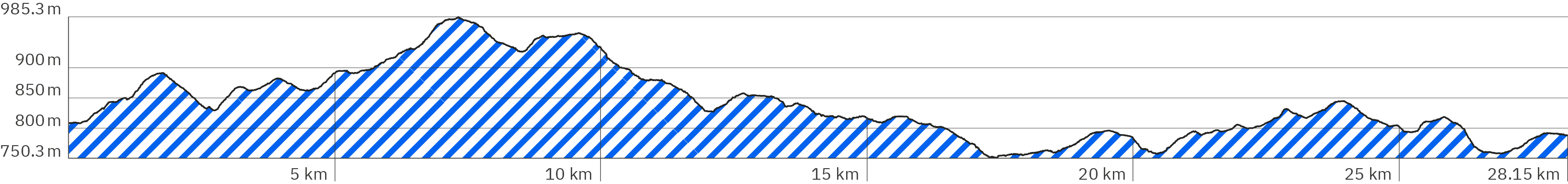
Length: approx. 28.2 km
Altitude: approx. 750m – 985m
Duration: approx. 10 hrs.
Peak travel season: May to September
Start: Rondell/Rennsteiggarten, Oberhof
End: Neustadt am Rennsteig
Pano tour photos: Sep. & Oct. 2011
Ad

Elevation curve – Stage 3:
Interactive Panoramic Tour:
Legend – 360° Panoramic Tour

Main path forward

Main path backward

Detour forward

Detour backward

Explore forward

Explore backward
Legend – Map
Waypoint
Start / End
Detour
Explore
Point with extra info
Rest
Path type
Turnoff
Shelter
Accommodation
Camping
Public transport
Supermarket
View
Lavatory
Drinking water
ATM
Parking
Attention
Activity
Snack bar / Restaurant
My 3rd stage on the Rennsteig leads from Oberhof to Neustadt am Rennsteig (Großwiesenbach). (Of course, there are also different stage routes. According to Wikipedia, the 3rd stage leads 2 km further to the village of Kahlert. And if you divide the Rennsteig into more than 6 stages, you naturally have completely different lengths.)
Important: The actual start is at the „Rondell“, about 2 km away from Oberhof. There is also a bus stop to get to the starting point by bus. Just like at the end of the virtual panorama tour for the 2nd Stage you find here (marked with yellow) also the way walking from Oberhof, starting from Hotel Vergissmeinnicht (Booking.com link)* where I stayed. The Wagners Sporthotel Oberhof (Booking.com link)*, that accommodated my at the end of my first attempt is a bit closer at the edge of the forest.
The stage starts uphill on a slightly muddy gravel path. After steeper climbs in the first third (up to 985 meters), the rest of the way leads mostly downhill (down to 750 meters) – always with short steeper climbs in between. It is mostly walked in the shade of dense forest.
Level of difficulty:
Easy to medium – due to the length of the stage, physically challenging and demanding.
Provisions:
As always on the Rennsteig, it is important to carry at least 2 liters of water with you – and to fill up the supply regularly at the snack bars. Energy bars, fruit and sandwiches from breakfast are always good. But also on the 3rd stage there are nice restaurants and beer gardens to rest and strengthen yourself. However, one should not make the provision for the way solely dependent on this, since they are not always open. As always, it makes sense to call them beforehand to see if they’re open.
Snack bars, restaurants & accommodation on the way:
Suhler Hütte – around km 6.8 (Google link also in pano), Website Suhler Hütte – restaurant & accommodation not visited by me
Rasthaus & Waldhotel Schmücke with the snack bar „Joel’s Biergarten“ – around km 7.3 (Google links also in pano), website schmuecke.eu
Bahnhof Rennsteig around km 14.9 (Google link to the restaurant also in pano) Website bahnhofrennsteig.de
Waldbaude „Großer Dreiherrenstein“ – around km 20.5
(Google link also in pano), restaurant and accommodation website waldbaudegrosserdreiherrenstein.de
Shelters:
Unlike the previous stages, most of the shelters on this stage are not marked on Google Maps. They are marked with the shelter icon in the map of the panorama tour.
Parkplatz Sommerwiese bei Oberhof – around km 1.1 (link to Google Maps)
Suhler Ausspanne – around km 3.7 (link to Google Maps) At the time of my tour a shelter, today apparently altered and, thus, not varified by me
Not shelter, but roofed: Plänckners Aussicht – around km 4.6 (Google link also in pano) Roofed observation platform
Shelter – around km 5.8
Shelter close to the Herbert-Roth-Denkmal – around km 8.0
(Google link also in pano)
Schutzhütte close to the Bus stop Mordfleck – around km 9.4
(Google link also in pano)
Shelter Alte Tränke – ca. bei km 10.8 (Google link also in pano), tables and benches with backrest, fireplace
Shelter – around km 13.7
Shelter at the rest „Bahnhof Allzunah“ – around km 17.5
(Googl link also in pano)
Shelter – around km 19.2
Shelter – around km 22.3
Shelter – around km 23.8
Sehenswertes:
Plänckners Aussicht – around km 4.6 (Google link also in pano) – roofed observation platform with a wide view over the country
Mittelpunkt des Rennsteigs (center point of the Rennsteig) – around km 21.0 (Google link also in pano)
Bus & Bahn / Anfahrt:
You reach the start of the stage with Bus 422 from Oberhof (link to public transport website mbb-mgn.de). To Oberhof you can get by car or with a bus from one of the bigger villages nearby with a train station like the city of Gotha.
Public transport along the 3rd stage:
Bus stop Rondell/Rennsteigarten – Oberhof – at km 0.0
(Google link also in pano) Bus 422 from / to Oberhof.
Bus stop Mordfleck – around km 9.4 (Google link also in pano), Bus R, public transport website sngonline.de
Train station Bahnhof Rennsteig – around km 14.9 (Google link also in pano) regional train RB46, train website sued-thueringen-bahn.de
Bus stop Rennsteig Bahnhof –around km 15.1 (Google link also in pano) buses 300 and 307 – public transport website iov-ilmenau.de
Bus stop „Dreiherrenstein b. Frauenwalde“ – around km 20.5
(Google link also in pano), public transport website iov-ilmenau.de
Accomodation at the start of the stage in Oberhof:
For the start of the stage I chose the Hotel Vergissmeinnicht (Booking.com link)*, Goole Maps link, website haus-vergissmeinnicht.de. The Wagners Sporthotel Oberhof (Booking.com link)*, Google Maps link, Website sporthotel-oberhof.de, which accommodated me at the end of my first attempt is a bit closer to the stage’s start at the edge of the forest. Closer to the start, about 200 meters away from the Rondell, there is only the A&S Ferienzentrum Oberhof (Booking.com link)*. Oberhof (link to Google Maps) has a wide range of options to stay over.
Accommodation at the end of the stage in Neustadt am Rennsteig (Großbreitenbach):
Auch Neustadt am Rennsteig (Google-Link) bietet unterschiedliche Übernachtungsmöglichkeiten. Auf meiner Wanderung beherbergte mich der Hotel-Gasthof Hubertus (Google-Link) (Website: rennsteighotel-hubertus.de)
Rennsteig – Stage 3 – Pano rsb-187
> Start of the 3rd stage (follow the green arrow)
> Bus stop Rondell/Rennsteiggarten – Oberhof (Google link also in pano – turn pano 90° left)
> For hotels take the bus to Oberhof or follow the orange arrows in the panorama back to Oberhof (approx. 2 km)
> The stage starts on a loamy forest gravel path, a little steeper uphill
Rennsteig – Stage 3 – Pano rsc-2
> Loamy forest gravel path, steeper uphill
Rennsteig – Stage 3 – Pano rsc-4
> Turn left
> It gets flatter
Rennsteig – Stage 3 – Pano rsc-5
> Simple benches in the shade without backrests
> Continue straight ahead
Rennsteig – Stage 3 – Pano rsc-6
> Bench with backrest
> Continue straight ahead
> Slightly uphill
Rennsteig – Stage 3 – Pano rsc-8
> Slightly downhill
Rennsteig – Stage 3 – Pano rsc-10
> Shelter (turn Pano 160° to the right)
> Tables, benches with backrest
> Parking Sommerwiese bei Oberhof (Google link also in pano)
Rennsteig – Stage 3 – Pano rsc-11
> Turn left after the parking lot
> Attention when crossing the country road
Rennsteig – Stage 3 – Pano rsc-12
> Turn semi left into the forest path
Rennsteig – Stage 3 – Pano rsc-13
> Slightly steeper uphill
Rennsteig – Stage 3 – Pano rsc-15
> Keep right
Rennsteig – Stage 3 – Pano rsc-16
> Attention when crossing the country road
> Continue on the forest path
Rennsteig – Stage 3 – Pano rsc-18
> Keep left
Rennsteig – Stage 3 – Pano rsc-19
> Steep uphill, then down again
> More uneven and loamy
Rennsteig – Stage 3 – Pano rsc-20
> Continue straight ahead
> On a level, passable forest path
> Slightly steeper uphill, then it gets flatter
Rennsteig – Stage 3 – Pano rsc-21
> Continue straight ahead
Rennsteig – Stage 3 – Pano rsc-22
> Continue straight ahead
Rennsteig – Stage 3 – Pano rsc-23
> Shelter Suhler Ausspanne (Google link also in pano)
> A refuge at the time of my hike – newly built in the meantime, therefore not verified
> Continue halfway to the left
Rennsteig – Stage 3 – Pano rsc-24
> Turn left
Rennsteig – Stage 3 – Pano rsc-25
> Path becomes more rocky
> Steeper uphill
Rennsteig – Stage 3 – Pano rsc-27
> Path even more uneven
> Even steeper uphill
> Continue straight ahead
Rennsteig – Stage 3 – Pano rsc-28
> Continue to the right on a drivable forest path
> It gets flatter again
Rennsteig – Stage 3 – Pano rsc-31
> Plänckners Aussicht (Google link also in pano) – covered viewing platform
> Tables and benches without a roof
> Steep uphill, then downhill again
Rennsteig – Stage 3 – Pano rsc-33
> Continue to the right on narrower forest path
> More loamy and steeper downhill
Rennsteig – Stage 3 – Pano rsc-34
> Uphill again
Rennsteig – Stage 3 – Pano rsc-35
> Turn right
> Uneven downhill on a narrow, loamy forest path criss-crossed with roots
Rennsteig – Stage 3 – Pano rsc-37
> Continue straight ahead / keep semi right
> Paved path
Rennsteig – Stage 3 – Pano rsc-38
> Shelter
> Benches with backrest
Rennsteig – Stage 3 – Pano rsc-39
> Parking lot at the L1129 state road
> Slightly rockier, slightly uphill
Rennsteig – Stage 3 – Pano rsc-41
> Slightly downhill
Rennsteig – Stage 3 – Pano rsc-42
> Long slightly uphill
Rennsteig – Stage 3 – Pano rsc-47
> Continue straight ahead
> Turnoff to „Suhler Hütte“ (Google link also in pano) Website-Link Suhler Hütte – restaurant & accommodation, not visited / verified by me
Rennsteig – Stage 3 – Pano rsc-48
> Slightly uphill on narrow gravel forest path
Rennsteig – Stage 3 – Pano rsc-50
> Turnoff left to restaurant & hotel „Waldhotel Schmücke“ and beer garden / grill „Joel’s Biergarten“ (follow blue arrow)
Rennsteig – Stage 3 – Pano rsc-53 (mini detour Guesthouse & Snack bar – blue arrows)
> Bus stop Schmücke Gasthaus – Gehlberg
(Google link also in pano, public transport website sngonline.de)
> Parking
> Attention crossing the road
Rennsteig – Stage 3 – Pano rsc-52 (mini detour Guesthouse & Snack bar – blue arrows)
> Gasthaus & Waldhotel Schmücke (Google link also in pano), website schmuecke.eu
> Snack bar „Joel’s Biergarten“ (Google link also in pano)
Rennsteig – Stage 3 – Pano rsc-51
> Coming from the guesthouse: after crossing the country road keep left
> Keep on narrow uneven forest path parallel to the country road – ups and downs over many roots
Rennsteig – Stage 3 – Pano rsc-58
> Stay left (alongside the country road)
Rennsteig – Stage 3 – Pano rsc-59
> Shelter close to the memorial Herbert-Roth-Denkmal (Google link also in pano)
> Tables and benches with backrests
> Keep semi right after the parking lot
Rennsteig – Stage 3 – Pano rsc-60
> Plain dirt road
Rennsteig – Stage 3 – Pano rsc-61
> Keep left
> Path becomes narrow, earthy and criss-crossed by roots
Rennsteig – Stage 3 – Pano rsc-67
> Continue along the country road
> Hikers‘ Parking Wanderparkplatz Mordfleck (Google link also in pano)
Rennsteig – Stage 3 – Pano rsc-68
> Continue alongside country road on soft meadow path
Rennsteig – Stage 3 – Pano rsc-69
> Bus stop Mordfleck (Bus R) (Google link also in pano), public transport webseite sngonline.de
> Turn left and cross the country road
Rennsteig – Stage 3 – Pano rsc-70
> Shelter at the Bus stop Mordfleck (Google link also in pano), table and benches with backrest
> Continue slightly uphill on a narrow forest path left of the country road
Rennsteig – Stage 3 – Pano rsc-72
> Turn right onto the footpath
Rennsteig – Stage 3 – Pano rsc-73
> Very uneven, soft footpath on grass, slippery and sometimes steeper
Rennsteig – Stage 3 – Pano rsc-74
> Continue straight ahead alongside the country road
> Narrow, somewhat firmer path, more downhill
Rennsteig – Stage 3 – Pano rsc-78
> Continue straight ahead (left of the country road) on a wide, drivable gravel road
Rennsteig – Stage 3 – Pano rsc-79
> Straight ahead into the forest, narrow gravel path, sloping gullies on the sides, slightly uphill
Rennsteig – Stage 3 – Pano rsc-81
> Shelter Alte Tränke (Google link also in pano)
> „Obere Nahequelle“ (upper spring of the river Nahe)
> Tables and benches with backrests, fireplace
Rennsteig – Stage 3 – Pano rsc-82
> Slightly uphill on narrow, slightly uneven forest path
Rennsteig – Stage 3 – Pano rsc-84
> Slightly downhill
Rennsteig – Stage 3 – Pano rsc-89
> Slightly uphill
Rennsteig – Stage 3 – Pano rsc-90
> Continue straight ahead, slightly downhill
Rennsteig – Stage 3 – Pano rsc-92
> Bench with backrest
> Turn slightly to the left, further alongside the country road, slightly uphill on the narrow forest path
Rennsteig – Stage 3 – Pano rsc-93
> Continue alongside the country road
> Mostly flat
Rennsteig – Stage 3 – Pano rsc-97
> Slightly downhill
Rennsteig – Stage 3 – Pano rsc-99
> Turn right, continue on drivable gravel road, slightly uphill
Rennsteig – Stage 3 – Pano rsc-101
> Shelter, table and benches with backrest
> Turn left into the narrow forest path
Rennsteig – Stage 3 – Pano rsc-103
> Path becomes more uneven, with more roots, alternating slightly uphill and downhill
Rennsteig – Stage 3 – Pano rsc-106
> Cross the road and continue straight ahead
Rennsteig – Stage 3 – Pano rsc-107
> Slightly downhill
Rennsteig – Stage 3 – Pano rsc-108
> Table and benches with backrest
Rennsteig – Stage 3 – Pano rsc-109
> Cross the railway tracks, continue on the left road side
Rennsteig – Stage 3 – Pano rsc-110
> Back on the narrow, slightly uneven forest path, slightly downhill
Rennsteig – Stage 3 – Pano rsc-111
> Continue straight ahead, more uphill, again with more roots
Rennsteig – Stage 3 – Pano rsc-113
> Train station Rennsteig (Google link to restaurant also in pano)
info website bahnhofrennsteig.de
> Regional train RB46 (public transport website sued-thueringen-bahn.de
Rennsteig – Stage 3 – Pano rsc-114
> Turn right towards the road
> Narrow table and benches with backrest
Rennsteig – Stage 3 – Pano rsc-115
> Bus stop Rennsteig Bahnhof (Google link also in pano), buses 300 & 307 – public transport website iov-ilmenau.de
> Semi left across the road
Rennsteig – Stage 3 – Pano rsc-116
> Continue right of the road
> Firm path, flat
Rennsteig – Stage 3 – Pano rsc-117
> Follow the wide gravel path, even and flat
Rennsteig – Stage 3 – Pano rsc-120
> Table and benches with backrest
Rennsteig – Stage 3 – Pano rsc-121
> Turn right before the road, continue on the right of the road
> Path becomes narrower again
Rennsteig – Stage 3 – Pano rsc-123
> Semi left, cross the road
Rennsteig – Stage 3 – Pano rsc-124
> After the road again on a narrow, uneven forest path, slightly uphill
Rennsteig – Stage 3 – Pano rsc-127
> Semi right, cross the road
Rennsteig – Stage 3 – Pano rsc-128
> After crossing the road, continue on the forest path, a bit earthier and softer, slightly uphill, rather flat
Rennsteig – Stage 3 – Pano rsc-131
> Table and benches with backrests under a small roof
> Keep straight past the benches
Rennsteig – Stage 3 – Pano rsc-132
> Path more overgrown with grass, slightly downhill
Rennsteig – Stage 3 – Pano rsc-133
> Turn left through the trees
Rennsteig – Stage 3 – Pano rsc-134
> Shelter at the Rest „Bahnhof Allzunah“ (Google link also in pano)
> Turn right, continue along the road on a narrow trail
Rennsteig – Stage 3 – Pano rsc-137
> Continue straight along the road
Rennsteig – Stage 3 – Pano rsc-139
> Path becomes more uneven and a little steeper
Rennsteig – Stage 3 – Pano rsc-142
> Steep uphill, very soft, earthy forest trail, laced with roots and very muddy when wet
Rennsteig – Stage 3 – Pano rsc-144
> Cross the gravel path, turn left onto a wider forest path, slightly downhill
Rennsteig – Stage 3 – Pano rsc-146
> Slightly uphill
Rennsteig – Stage 3 – Pano rsc-148
> Cross the street, continue straight ahead
Rennsteig – Stage 3 – Pano rsc-149
> Wide drivable gravel road, slightly uphill
Rennsteig – Stage 3 – Pano rsc-150
> Shelter
Rennsteig – Stage 3 – Pano rsc-151
> Slightly downhill
Rennsteig – Stage 3 – Pano rsc-153
> Turn right into a smaller forest path
> Steeper uphill
Rennsteig – Stage 3 – Pano rsc-154
> Narrow bench
> Slightly downhill
Rennsteig – stage 3 – rsc-155
> Continue straight ahead, cross the street
Rennsteig – Stage 3 – Pano rsc-157
> Restaurant & guesthouse – Waldbaude „Großer Dreiherrenstein“ (Google link also in pano), website waldbaudegrosserdreiherrenstein.de
> Bus stop „Dreiherrenstein b. Frauenwalde“ (Google link also in pano), public transport website iov-ilmenau.de
> Semi left cross the road after the parking
Rennsteig – Stage 3 – Pano rsc-158
> Narrow table and benches with backrest
> Uphill on a rocky gravel path
Rennsteig – Stage 3 – Pano rsc-160
> Turn right onto a forest path slightly overgrown with grass
> More rocky and uphill
Rennsteig – Stage 3 – Pano rsc-162
> I wasn’t aware of the center point of the Rennsteig (Google link also in the pano) – here or maybe a few meters further, but at least there is a landmark here (turn the pano 90° to the right)
Rennsteig – Stage 3 – Pano rsc-164
> Slightly downhill
Rennsteig – Stage 3 – Pano rsc-166
> Continue straight ahead
> Table and benches with backrests under a small roof
Rennsteig – Stage 3 – Pano rsc-168
> The path becomes narrower, more wooded and uneven, alternation of short easy ascents and descents
Rennsteig – Stage 3 – Pano rsc-170
> Shelter
> Narrow table and benches with backrest
> Continue straight ahead and cross the street
Rennsteig – Stage 3 – Pano rsc-171
> After crossing the street, continue straight ahead
> Wide dirt road, slightly downhill
Rennsteig – Stage 3 – Pano rsc-172
> Slightly uphill
Rennsteig – Stage 3 – Pano rsc-173
> Keep left at the fork
> Slightly downhill
Rennsteig – Stage 3 – Pano rsc-174
> Slightly uphill
Rennsteig – Stage 3 – Pano rsc-175
> Slightly downhill
Rennsteig – Stage 3 – Pano rsc-177
> Turn left onto the small forest path
> Uneven, with more roots, stones and soft earth, steeper downhill, partly very narrow
Rennsteig – Stage 3 – Pano rsc-181
> Back on a clearer path, a little flatter and firm, further downhill
Rennsteig – Stage 3 – Pano rsc-182
> Keep left, continue on a wide, passable gravel road, further slightly downhill
Rennsteig – Stage 3 – Pano rsc-183
> Shelter, table and bench with backrest
> Continue straight ahead
Rennsteig – Stage 3 – Pano rsc-184
> Turn right, alongside the country road
> Soft meadow footpath, slightly downhill
Rennsteig – Stage 3 – Pano rsc-185
> Longer slightly uphill
Rennsteig – Stage 3 – Pano rsc-186
> Table and benches under a small roof
> Keep left at the fork
> Narrow solid path, rocky, slightly uphill
Rennsteig – Stage 3 – Pano rsc-189
> Wide view over the field
> Bench with backrest
> Slightly steeper uphill
Rennsteig – Stage 3 – Pano rsc-191
> Turn left
> On tar road, flatter
Rennsteig – Stage 3 – Pano rsc-192
> Turn right into the village
> Continue on the pavement
Rennsteig – Stage 3 – Pano rsd-1
> End of the 3rd stage in the town Neustadt am Rennsteig
> The accommodation during my hike was Hotel-Gasthof Hubertus (Google link also in pano), website rennsteighotel-hubertus.de, for further accommodation options see Google link
> Also starting point of the 4th stage – link also in pano
Rennsteig – Stage 3 – Walk from Oberhof to the start of the stage – Pano rsb-202
> End of the detour to Oberhof
> Hotel Vergissmeinnicht (Booking.com link)* – my hotel during my second attempt of the tour (Google link also in pano)
> Start of stage 3: at the Rondell (link in pano)
Rennsteig – Stage 3 – Walk from Oberhof to the start of the stage – Pano rsb-199
Description coming from Oberhof:
> Keep right, cross the street
Rennsteig – Stage 3 – Walk from Oberhof to the start of the stage – Pano rsb-197
Description coming from Oberhof:
> Turn left into the street
Rennsteig – Stage 3 – Walk from Oberhof to the start of the stage – Pano rsb-196
Description coming from Oberhof:
> Wagners Sporthotel Oberhof (Booking.com-Link)* – my accommodation during my first attempt (Google link also in pano)
> Turn left
Rennsteig – Stage 3 – Walk from Oberhof to the start of the stage – Pano rsb-195
Description coming from Oberhof:
> Turn right after the parking lot
> Keep on forest path
Rennsteig – Stage 3 – Walk from Oberhof to the start of the stage – Pano rsb-194
Description coming from Oberhof:
> Keep left
> Continue on the dirt road
Rennsteig – Stage 3 – Walk from Oberhof to the start of the stage – Pano rsb-193
Description coming from Oberhof:
> After the meadow down to the path
Rennsteig – Stage 3 – Walk from Oberhof to the start of the stage – Pano rsb-192
Description coming from Oberhof:
> Turn right
> Continue on gravel path
Rennsteig – Stage 3 – Walk from Oberhof to the start of the stage – Pano rsb-190
Description coming from Oberhof:
> Bench with backrest
> Steeper uphill
Rennsteig – Stage 3 – Walk from Oberhof to the start of the stage – Pano rsb-189
Description coming from Oberhof:
> Bench with backrest
Rennsteig – Stage 3 – Walk from Oberhof to the start of the stage – Pano rsb-188
Description coming from Oberhof:
> Continue on drivable path
Rennsteig – Stage 3 – Walk from Oberhof to the start of the stage – Panorsb-179
Description coming from Oberhof:
> Turn left to get to the start of the stage (from here follow green arrow)
> Shelter R Schutzhütte am Dietzel-Geba-Stein (Google link also in pano – Pano 180° drehen)
> Benches with backrest
Rennsteig – Stage 3 – Walk from Oberhof to the start of the stage – Pano rsb-185
Description coming from Oberhof:
> Monument Forstarbeiterdenkmal (Google link also in pano)
> Keep straight towards the bridge
Rennsteig – Stage 3 – Walk from Oberhof to the start of the stage – Pano rsb-186
> Monument Rondell (Google link also in pano)
Ad