Rennsteig
Hiking Trail: Rennsteig
Continent: Europe
Region: Central Europe
Countries: Germany
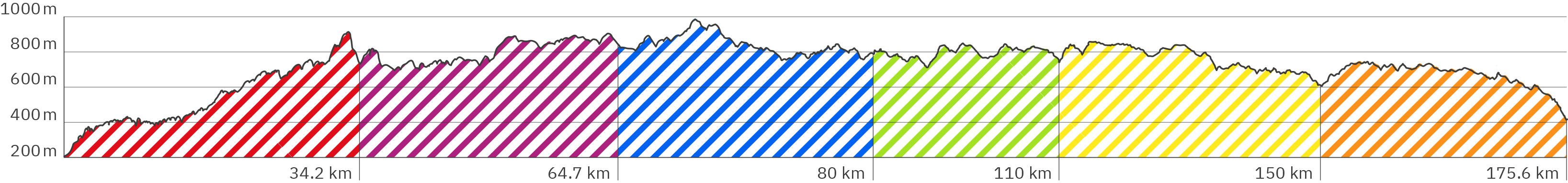
Length: approx. 176 km
Altitude: approx. 196 m – 983 m
Duration: 6 Days
Peak travel season: May to September
Start: Hörschel
End: Blankenstein (Saale)
Pano-Tour-Photos: Sep. & Oct. 2012
Ad

Elevation Curve – Full Tour
Brief Description Full Tour
The oldest long-distance hiking trail in Germany is not only called Rennsteig, it really feels like a run somehow. Its long stages require a high hiking speed. It leads mostly through forests - which, apart from a few vantage points, is the actual highlight of the trail. The trail is well developed. Many cyclists also tour the route. Unfortunately, encounters with fast mountain bikers on narrow, natural parts sometimes lead to some shocking moments. For hikers, however, there are always longer sections that run parallel to the even gravel or tar paths on earthy forest trails. The following slider with the stage pictures links to the individual stages - with key facts, short descriptions and each with a virtual panoramic tour to click through. Below the slider on this site you find some tips and recommendations for the tour as a whole.
Preparation – shoes & hiking sticks: Walking 170 kilometers in just 6 days means that you have to cover more than 30 km at some days. I strongly advise you to not use heavy mountain boots here. I did that mistake and had to interrupt the path after two stages. The strong mountain soles hit hard on long asphalt and gravel road parts. My knees hurt so badly and I wasn't able to continue the trail until a few weeks later. Soft soles and high breathability are a clear advantage on this path. "Running" on the Rennsteig partly has the character of Nordic walking. Hiking sticks that are suitable for this are also good here. Since there are a few steeper sections on natural ground, the clamps on telescopic poles must hold securely. (You should always test this starting a section.)
Preparation – Provisions Carry plenty of water with you, especially on hot summer days. Even if the forest provides a lot of shade, the long stages are a small marathon each. On the way there are always some restaurants and snack bars for food and refreshment. BUT: don't count on them being open. (And the 6th stage of the tour only offers very few options!) Along the way, there are many places to rest, including benches and tables to picnic.
Preparation – Clothing: Choosing the right clothes is a balancing act here. On the one hand, the fast walking pace and the long distances make you sweat a lot. On the other hand, the many wooded areas offer cooling shade - and you could feel cold quickly during the breaks. Depending on the weather, the wind sometimes blows cold across the open fields. Even walking quickly might not heat you up enough. In my opinion, a woolen hat, a thin scarf, fleece jacket and windbreaker should also be in your luggage, as well as short turnks and functional T-shirts that can deal with a lot of sweat.
Hiking destination: The Rennsteig leads in six stages from Hörschel (at the river Werra) (link to Google Maps) to Blankenstein (at the river Saale) (link to Google Maps).
Stage 1: Hörschel – Inselsberg
Stage 2: Inselsberg – Oberhof
Stage 3: Oberhof – Neustadt am Rennsteig
Stage 4: Neustadt am Rennsteig – Limbach / Scheibe-Alsbach
Stage 5: Limbach – Steinbach am Wald
Stage 6: Steinbach am Wald – Blankenstein (Saale)
Getting there & accommodation Public transport is generally available at all stage starts and end points – sometimes including a longer extra walk though. However, the busses run very sparsely in some of the more remote areas as well as very rarely in the late evening hours - which can sometimes become a problem on the long stages. You will find the links that I found in the respective stage descriptions. Basically, you can get quite far with a Google search and a more detailed search on the websites of the different bus companies in the region.
The Rennsteig hike should be well planned, especially when booking accommodation. At the end of some stages there is no accommodation directly available and you still have to walk a few kilometers to the next town if there is no bus to get you there.
If you hike on your own and take your car, there is now way around using public transport either from end to start or vice versa. Either way, I recommend an overnight stay in the guesthouse „Tor zum Rennsteig“ (link to Booking.com)*, to start early in the morning the day after you drove there with a solid breakfast.
*The links that are marked with an asterisk are affiliate links. The help to finance this site's production by advertisements. (After every link you'll find the respective brand to which the link leads you to.) With every click you help that this hiking website can stay alive and regularly offers new virtual panoramic tours of popular hiking trails. The same counts for the advertising banners, which are chosen as relevantly as possible for hikers and travelers.