Adam's Peak (Sri Pada)
Hiking Trail:
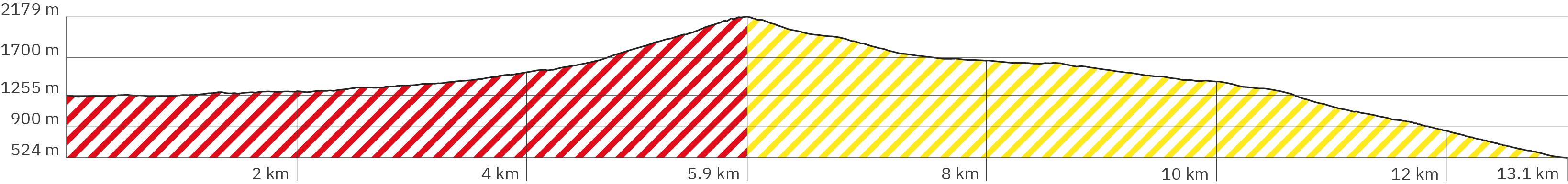
Dalhousie / Nallathanniya – Adam’s Peak – Ratnapura (Pawanella Car Park)
Continent: Asia
Region: South Asia
Countries: Sri Lanka
Length: approx. 12.9 km (of which approx. 6 km ascent)
Altitude: approx. 1,259m – 2,157m – 524m
Duration: approx. 10 hrs. (of which 5 hrs. ascent)
Peak travel season: December – May
Pano tour shot on 19 March 2018
Ad

Elevation Curve:
Interactive Panoramic Tour: (Click the green arrow to follow the trail up – and from the peak the yellow arrow down)
Legend – 360° Panoramic Tour

Main path forward

Main path backward

Detour forward

Detour backward

Explore forward

Explore backward
Legend – Map
Waypoint
Start/Endpunkt
Detour
Explore
Wegpunkt mit Zusatzinfo
Rest
Snack bar / Restaurant
Attention
ATM
Parking
View
Dusche
Activity
Internetzugang
Lavatory
Public transport
Supermarket
Shelter
Camping
Accommodation
Weg- beschaffenheit
Drinking water
Turnoff
Brief Description
Adam's Peak is Sri Lanka's second highest mountain. It is located inland, southwest of the center of the island, about 5 hours drive east of the capital Colombo. In Sinhalese it is called Sri Pada, which means holy foot. The reason: on the summit you'll find an approximately 1.8 meter long decorated footprint. It is a place of pilgrimage for different religions and to each it represents the footprint of a different saint or deity. The majority of pilgrims are Buddhists for whom it represents the footprint of Buddha. At one corner of the plateau there is an iron bell, which pilgrims strike as often as the number of climbs they have completed so far. The plateau has to be entered without shoes or headgear. However, I recommend keeping your socks on during the day, as the dark stones heat up very much in the sun.
Among hikers, Adam's Peak is known for its countless steps. Some speak of 4,500 steps, others of 5,200 steps, and still others of 5,500 steps. They are usually made of concrete, often higher than your average steps at home, and in the last quarter the stairs are extremely steep. And narrow. In consequence, shortly before sunrise there will be traffic jams and even a complete standstill because most people climb Adam's Peak at night in order to be on the summit in time for the rising sun. That's why the path is lined with neon lights.
Start / Finish: Most hikers choose Dalhousie or Nallathannyia (both names are used for the town) to start the tour from the northeast on the Hatton Road. There are countless hotels and restaurants and even more snack and souvenir stands at the beginning of the climb. Along the entire route you pass snack and tea stalls, on Hatton Road more so than on Rathnapura Road, the path's name on the southwest side of the mountain. I hiked during the day so I could take good photos of the trail. I also decided to climb up on the north side and descend on the south side. However, doing so can only be recommended to a certain extent. The heat during the day is extreme. And if you don't hike back to your starting point, you have to carry all your luggage with you.
Equipment recommendation:
- Hiking boots but not too heavy ones
- Hiking poles are actually a must-have. The many steps hit really hard on your knees, especially when walking back down.
- A fleece jacket, two extra shirts and a hat – whether at night or during the day, the winds on the summit can quickly cool your body down, especially after the sweaty climb.
- Sunscreen
- Headgear to protect against the sun
- Mosquito spray (especially on Rathnapura Road as the path also passes through dense and moist forests)
Food recommendation:
- Lots of water and something against cramps, such as magnesium supplements
- Buy something to drink along the way so that you don't run out of supplies at the end.
- Important: The snack shops are not always staffed.
Getting to Dalhousie / Nallathanniya – Train & Bus / Taxi / Tuk-Tuk: Public transport in Sri Lanka is a sight itself. In the mountains, old trains wind their way through endless tea plantations. Some travelers take advantage of the low security regulations and hang themselves out the door of the carriage to admire the vast panoramic views of misty valleys. Of course, there are also more modern and faster trains on the main routes. On the other hand, the buses that take you the last stretch to Dalhousie, are less idyllic and more of an exciting feast for all the senses throughout Sri Lanka. Just like the many small tuk-tuks.
Of course, the journey depends on your starting point on the island. Here you first take the train to Hatton, more precisely Hatton Railway StationDuring peak pilgrimage season buses are leaving more frequently for Dalhousie / Nallathannyia from Hatton and take around 80 minutes. Hatton Bus Stand lies around 10 minutes walking distance from the train station. Alternatives are tuk-tuks and of course taxis. Important: you should allow more time for train journeys and changes.
Departure in Rathnapurna – Tuk-Tuk: I finished my hike on the southwest side of Adam's Peak at Pavanella Car Park. Due to the late hour, I saved myself another 20 minutes of hiking to the temple complex Sri Rajasingharama Purana Rajamaha Viharaya. Instead, I took a tuk-tuk that took me across Ratnapura to my hotel - first over small bumpy roads and then an hour or so through very dense and exhaust-filled traffic. My driver got lost properly. My recommendation: directly use your smartphone navigation system and, if necessary, give friendly directions.
Way points describe the path starting in Dalhousie / Nallathanniya.
Adam’s Peak – Pano ap-1
> White Elephant Hotel (Google link also in pano)
> Following the road backwards around the right-hand bend: River View Whatsala Inn (Google link also in pano)
Adam’s Peak – Pano ap-2
> Hotel „Queen’s Ark“ (Google link also in pano)
Adam’s Peak – Pano ap-3
> White House Guest House (Google link also in pano)
Adam’s Peak – Pano ap-4
> My start of the hike in Dalhousie or Nallathanniya was the Hotel Grand Adam’s Peak (Google link also in pano)
> Follow the green arrow uphill – from the summit, follow the yellow arrows down the other side
> Slightly uphill on asphalt (Main Street)
> Follow purple arrow backwards to explore three more panos with hotels
Adam’s Peak – Pano ap-5
> Sisilasa Restaurant (Google link also in pano)
Adam’s Peak – Pano ap-7
> Adam’s Peak Inn Hotel & Family Restaurant (Google link also in pano)
Adam’s Peak – Pano ap-8
> Daddy’s Guest Home Bar & Family Restaurant (Google link also in pano)
> Siumi Rest (Google link also in pano)
Adam’s Peak – Pano ap-9
> Shopping possibility in Mini-Coop (Google link also in pano)
> Restaurants Galle Café & Bakery, The Peak Residents and no1. Galle Café (Google links also in pano)
> Paradise Entrance Hotel (Google link also in pano)
Adam’s Peak – Pano ap-10
> White archway (Google link also in pano), probably built after my tour
> Various options for buying provisions and souvenirs
Adam’s Peak – Pano ap-11
> Bus stop Nallathanniya / Dalhousie (Google link also in pano)
> Polce station (Google link also in pano)
Adam’s Peak – Pano ap-12
> ATM (Google link also in pano)
> Vijitha Hotel and Bakery (Google link also in pano)
> Slightly downhill
Adam’s Peak – Pano ap-13
> Nallathanniya Buddha Statue (Google link also in pano)
> Souvenirs and provisions
> Stronger downwards
Adam’s Peak – Pano ap-14
> Souvenirs and provisions
Adam’s Peak – Pano ap-15
> Delhouse Bridge (Google link also in pano) across the river Seetha Gangula
> There should be a shower station here (Google link also in pano) which is not recommended though
> Souvenirs and provisions
> Flat over the bridge, then more uphill
Adam’s Peak – Pano ap-16
> Accommodation: Singh Bro’s (Google link also in pano)
> Kiosk for provisions
> It feels like the first real steps here – which will be followed by many more
Adam’s Peak – Pano ap-17
> Numerous shopping opportunities for souvenirs and provisions
> Flat and level further
Adam’s Peak – Pano ap-18
> Shopping for souvenirs and provisions for the journey
> Slightly uphill
Adam’s Peak – Pano ap-20
> Short piece with flat steps of irregular length
Adam’s Peak – Pano ap-21
> Small temple-like building
> Flat further
Adam’s Peak – Pano ap-22
> Slightly uphill on a level paved path
Adam’s Peak – Pano ap-23
> Slightly uphill with a few steps on a level, loamy gravel path
> Stalls selling souvenirs
Adam’s Peak – Pano ap-24
> Stalls with souvenirs
Adam’s Peak – Pano ap-25
> Stalls with souvenirs and provisions
Adam’s Peak – Pano ap-26
> More uphill, a bit rocky and bumpy, dusty clay trail
Adam’s Peak – Pano ap-27
> Possibility to rest on an iron bench without a backrest
Adam’s Peak – Pano ap-28
> Public toilets (not verified)
> Larger, hall-like canopy
> Continue flat on a level clay path
Adam’s Peak – Pano ap-29
> Slightly uphill with a few steps
> Stalls selling sweets and souvenirs
> Benches with backrest
Adam’s Peak – Pano ap-30
> Slightly uphill, slightly uneven
> Stalls selling souvenirs
> Benches with backrest
Adam’s Peak – Pano ap-31
> Slightly uphill, a few steps, mix of clay and concrete path
Adam’s Peak – Pano ap-32
> Stronger downhill on longer flat stone and clay steps
> Numerous stalls mainly selling souvenirs
Adam’s Peak – Pano ap-33
> Iron benches with backrest
> Stronger downhill on uneven stone and clay steps
> Numerous stalls
Adam’s Peak – Pano ap-34
> Public toilets (Google link also in pano)
> Slightly downhill, uneven with occasional steps
> Stalls selling souvenirs and provisions
Adam’s Peak – Pano ap-35
> Place of worship and historic archway Makara Thorana (Google link also in pano)
> Large reclining Buddha statue
> Wildlife Department (Google link also in pano)
> Slightly uphill, slightly uneven on a stony clay/gravel path and a short concrete bridge
Adam’s Peak – Pano ap-36
> Narrow wooden benches
> Stronger uphill, mix of steps and short uneven flat sections
> Sales stand with provisions for the journey
Adam’s Peak – Pano ap-37
> More uphill, irregular, higher steps with rocky clay/gravel
Adam’s Peak – Pano ap-39
> Bridge over the Seetha Gangula
> Short piece with steep stairs
Adam’s Peak – Pano ap-40
> Turn off to Japan Peace Temple on steep specially designed stairs (Google link also in pano) – recommended, since the paths cross at the temple
> Continue up the normal path on short steps, regularly interrupted by flat sections
Adam’s Peak – Pano ap-42
> Flat and even further on a concrete path
> Sporadic stands with souvenirs and provisions for the journey
Adam’s Peak – Pano ap-43
> Intersection with the step path between Japan Peace Temple (Google link also in pano) and Japan Peace Pagoda (Google link also in pano)
> The main path also leads to the pagoda on a level concrete path, more steeply uphill
Adam’s Peak – Pano ap-44
> Stretched concrete stairs
Adam’s Peak – Pano ap-45
> Turn off to Japan Peace Pagoda (Google link also in pano) (flat on gravel)
> Bench with backrest
> Stalls – food and souvenirs
> Sign for toilets (not checked)
Adam’s Peak – Pano ap-46
> Sight Nishshanka Lena (Google link also in pano), which means something like „calm down“ – praying stone monks under a rock
> Slightly uphill on level concrete
Adam’s Peak – Pano ap-47
> Mix of longer steps and short flat sections on concrete
> Stalls for souvenirs
Adam’s Peak – Pano ap-48
> Public toilets – turn pano 90° to the right (Google link also in pano)
> snacks
> Mix of short stairs and flat longer sections on concrete
> Stalls for souvenirs
Adam’s Peak – Pano ap-49
> Buddhist place of worship
> Snacks and souvenirs
Adam’s Peak – Pano ap-50
> Canopies at a hotel and a shop for souvenirs and tea
Adam’s Peak – Pano ap-51
> Possibility to rest on narrow wooden benches – possibly also on plastic chairs, which are probably part of the stall for souvenirs and snacks
> Mix of slightly longer stairs and short flat sections on concrete
Adam’s Peak – Pano ap-52
> Possibility to rest on narrow wooden benches
> Sales stand – rather souvenirs
> Longer steep stairs
Adam’s Peak – Pano ap-53
> Large shelter for pilgrimr (Google link also in pano)
> Toilets (not verified)
> Mixture of long, flat passages, more steeply uphill, and occasional steps
Adam’s Peak – Pano ap-54
> Place for ritual baths in the Seetha Gangula river (Google link also in pano)
> More uphill, mix of steep and flat stairs
Adam’s Peak – Pano ap-55
> Steps a little less steep
> Stalls – mostly sweets and souvenirs
Adam’s Peak – Pano ap-56
> Steeper uphill on higher concrete steps
Adam’s Peak – Pano ap-57
> Steeper uphill on less high cobblestone steps
Adam’s Peak – Pano ap-58
> Rest on narrow wooden benches
> Larger shelter for pilgrims (Google link also in pano)
> Toilet not verified
> Selling stand for provisions
> Slightly flatter on a slightly stony clay path
Adam’s Peak – Pano ap-59
> A long stretch steeply uphill on high concrete steps
> Snack stand
Adam’s Peak – Pano ap-60
> Narrower path in the middle divided by an iron bar: the rule is right up (left down)
> Continue steeply uphill on high concrete steps
Adam’s Peak – Pano ap-62
> Less steep on stretched concrete stairs
Adam’s Peak – Pano ap-63
> Steep with short and high concrete steps
Adam’s Peak – Pano ap-64
> Sign for toilet (not verified)
Adam’s Peak – Pano ap-66
> Public toilet (not verified) (Google link also in pano)
> Two stone chairs with backrest
> Snack stand
> Slightly less steep on wider concrete steps
Adam’s Peak – Pano ap-67
> Steeper uphill but on slightly flatter concrete steps
Adam’s Peak – Pano ap-68
> Indikatupana (Google link also in pano – with background info about the white threads)
> Shelter with narrow benches at a stall for snacks and drinks
> Narrow bench also outside
> Stairs become narrower, steep on concrete steps that are not too high
Adam’s Peak – Pano ap-69
> Canopy next to a building
Adam’s Peak – Pano ap-70
> Indikatupana Buddha Statue (Google link also in pano)
> Police post (Google link also in pano)
> Junction (onto Adiyamala Thenna Geththampana footpath) but continue left up the steps
> Slightly less steep, flatter concrete steps
Adam’s Peak – Pano ap-71
> Again steeper, flatter concrete steps
Adam’s Peak – Pano ap-72
> Larger shelter
Adam’s Peak – Pano ap-73
> Canopy with tables and benches
Adam’s Peak – Pano ap-74
> Very narrow and steep staircase, separated by iron handrail in the middle – with instructions to walk up on the right-hand side
> Traffic jam very likely
Adam’s Peak – Pano ap-75
> Still very narrow and steep on high steps
Adam’s Peak – Pano ap-76
> Slightly less steep with flatter, slightly longer steps
Adam’s Peak – Pano ap-77
> Shelter at a snack sale
> Again very steep stairs with high steps
> Attention: steps partially broken, stairs supplemented with wooden boards
Adam’s Peak – Pano ap-78
> Sign for toilet (not verified)
Adam’s Peak – Pano ap-79
> Snack and souvenir sales stall (Google link also in pano)
> Very steep stairs
Adam’s Peak – Pano ap-81
> Very steep stairs
Adam’s Peak – Pano ap-81
> Stairs a little less steep
Adam’s Peak – Pano ap-82
> Stairs again very steep with high steps
Adam’s Peak – Pano ap-84
> Complex of buildings around the sacred peak
> Shoes and hats are supposed to be put down here, but many only did so on the upper platform
> The stairs continue steeply uphill
Adam’s Peak – Pano ap-85
> In the complex of buildings surrounding the sacred peak, there are large rooms where pilgrims can rest on the carpeted floor
> Rest on large steps – end of „Hatton Road“
> Again, urgent notice to remove shoes and headgear
> Important: the dark stone slabs get very hot in the sun, which is almost unbearable barefoot
> Follow the yellow arrow for the descent
Adam’s Peak – Pano ap-87
> Summit temple terrace south-west side
> Enter without shoes and hat
> Stone slabs very hot in the sun (therefore I left my socks on)
Adam’s Peak – Pano ap-88
> Summit temple terrace south-east side
> Stair exit of the temple with Buddha’s footprint
Adam’s Peak – Pano ap-89
> Summit temple terrace east side
> Stair exit of the temple with Buddha’s footprint
Adam’s Peak – Pano ap-92
> Summit temple terrace north-east side
> Bells rung by pilgrims – as many times as they have climbed the mountain
> Sacred hearth Dolos Mahe Pahana (Google link also in pano)
> Follow the yellow pano arrow for the pano tour descent
Adam’s Peak – Pano ap-91
> Passage through the small building with Buddha’s (oversized) footprint
> Photography is prohibited inside
> End of ascent
> Follow the yellow pano arrow for the pano tour descent
Adam’s Peak – Pano ap-86
> Follow the pano yellow arrow for the pano tour descent
> Rest on large, long concrete steps
> Entrance to the summit platform with the small building to Buddha’s footprint – enter only without hat and shoes (however, the dark stone slabs get very hot in the sun)
Adam’s Peak – Pano ap-93
> Start of descent on Ratnapura Road (follow yellow arrow in pano)
> Steep concrete stairs
Adam’s Peak – Pano ap-94
> Extremely steep concrete stairs downhill
> Narrow staircase divided by iron rail to separate ascending and descending (walk on the right side)
Adam’s Peak – Pano ap-96
> Short flat section with long steps
Adam’s Peak – Pano ap-97
> Small Buddha statue and wide view over the country (if it’s not cloudy of course)
> Downhill on very steep concrete steps
Adam’s Peak – Pano ap-99
> Shelter at the Ahala Kanuwa Shop with snacks und souvenirs (Google link also in pano)
> Steep downhill on two-part concrete stairs with iron handrails
Adam’s Peak – Pano ap-100
> Less steep downhill on concrete stairs, undivided without rails
Adam’s Peak – Pano ap-101
> Flatter descent on concrete stairs, with slightly longer steps
Adam’s Peak – Pano ap-102
> Apparently a turn off to bypass the summit (on the Adiyamala Thenna Geththampana footpath) (not verified)
> Continue straight ahead
Adam’s Peak – Pano ap-103
> Large resting hall Adiya mala Thenna (Google link also in pano)
> Continue flat on an even clay path
Adam’s Peak – Pano ap-104
> Restaurant and restrooms (unverified) Adiyamalathanna Co-Operative Restaurant (Google link also in pano)
> Short uphill section, flat concrete steps
Adam’s Peak – Pano ap-105
> Steeper downhill on concrete steps
Adam’s Peak – Pano ap-106
> Steep downhill on concrete steps, narrow stairs without handrail
Adam’s Peak – Pano ap-108
> Shelter at the snack stall Meellamalakandura Shop (Google link also in pano)
> Steeper downhill on narrow concrete stairs
Adam’s Peak – Pano ap-109
> Very steep downhill on narrow concrete stairs
Adam’s Peak – Pano ap-110
> Steep downhill on narrow concrete stairs with iron handrail
Adam’s Peak – Pano ap-111
> Steep downhill on narrow concrete stairs without rails
Adam’s Peak – Pano ap-112
> Water point – drinkability not verified
> Slightly less steep downhill on narrow concrete stairs
Adam’s Peak – Pano ap-114
> Slightly less steep descent on short, flat, slightly stony pieces of clay, interrupted by short concrete steps
Adam’s Peak – Pano ap-115
> Sight: Makara Thorana – Rathnapura Road (Google link also in pano)
> Flat, level clay course, then slightly steep downhill on longer concrete steps
Adam’s Peak – Pano ap-117
> According to Google: Haramitipana Hospital – not verified (Google link also in pano)
> Possible shelter
Adam’s Peak – Pano ap-118
> Steep uphill on narrow concrete stairs
Adam’s Peak – Pano ap-119
> Restaurant (closed during the day on my tour) (Google link also in pano)
> Shop for snacks and souvenirs
> Rest on wooden benches without backrests
> Very steep uphill climb on narrow concrete stairs with iron rail on one side only
Adam’s Peak – Pano ap-120
> Heramitipana Cooperative Restaurant (Google link also in pano)
> Heramitipaana Ambalama overnight accommodation in a large hall for pilgrims (Google link also in pano)
> Continue flat on level clay ground
Adam’s Peak – Pano ap-121
> Steep downhill on narrow concrete stairs
Adam’s Peak – Pano ap-122
> Downhill alternately short concrete stairs and slightly flatter on slightly stony clay
Adam’s Peak – Pano ap-123
> Flatter downhill, short ascending concrete stairs then concrete stairs downhill again
Adam’s Peak – Pano ap-124
> Small bridge Heen Gangula (Google link also in pano)
> Slightly uphill on narrow concrete stairs
Adam’s Peak – Pano ap-125
> After short flatter pieces of clay, steeper downhill on concrete steps
Adam’s Peak – Pano ap-127
> After a short flat piece of clay, steeply downhill on concrete stairs
Adam’s Peak – Pano ap-128
> Small bridge at Seetha Gangula with sea of rocks on the river (Google link also in pano)
> Possible small shelter
> Steep uphill on narrow concrete stairs
Adam’s Peak – Pano ap-129
> According to Google near here: Seetha Gangula Waterfall (Google link also in pano) – not seen on my tour
> Flatter on clay, natural stone pavement and a short climb
Adam’s Peak – Pano ap-130
> Slightly downhill on long concrete steps
Adam’s Peak – Pano ap-131
> Short flat section on concrete, then concrete steps uphill
Adam’s Peak – Pano ap-132
> Short flat section on clay, then concrete steps steeply uphill
Adam’s Peak – Pano ap-133
> Less steep, concrete steps uphill
Adam’s Peak – Pano ap-134
> Slightly downhill on a narrow clay path with a few steps
Adam’s Peak – Pano ap-137
> Downhill on flat, longer concrete steps
Adam’s Peak – Pano ap-138
> Steep descent on narrow concrete stairs with iron rail
Adam’s Peak – Pano ap-139
> Flatter downhill, on longer concrete steps, then steeper uphill
Adam’s Peak – Pano ap-140
> Short, flat and narrow concrete plateau with a view
Adam’s Peak – Pano ap-141
> Steep downhill on narrow concrete stairs
Adam’s Peak – Pano ap-143
> Slightly less steep, with occasional short flat sections
Adam’s Peak – Pano ap-144
> Short narrow concrete bridge Dharmarajagala (Google link also in pano) with a view and iron rails
> Flatter descent, irregular on clay gravel and concrete steps
Adam’s Peak – Pano ap-146
> Slightly steeper downhill on narrow concrete stairs without rails
Adam’s Peak – Pano ap-147
> After a long flat section on clay, slightly steep concrete stairs
Adam’s Peak – Pano ap-148
> Continue flat on a stone path with a few concrete steps
Adam’s Peak – Pano ap-149
> Religious landmark Idi Katu Paana respectively Geththampana (Google links also in pano)
> Pilgrim rest Geththampana Ambalama (Google link also in pano)
> Possibly a sales stand with snacks (Google link also in pano)
> Attention: continue flat over rocks with larger crevice
Adam’s Peak – Pano ap-150
> Slightly downhill on concrete with steps and short flat sections
Adam’s Peak – Pano ap-152
> A few steps up then steeper downhill on concrete steps
Adam’s Peak – Pano ap-154
> Short flat section on narrow clay path with stones then downhill on concrete steps
Adam’s Peak – Pano ap-156
> Up a few flat concrete steps, then a less steep descent
Adam’s Peak – Pano ap-157
> Little longer uphill on flat concrete steps
Adam’s Peak – Pano ap-160
> After a short flat section downhill on flat concrete steps
Adam’s Peak – Pano ap-161
> Steeper downhill on narrow concrete stairs
Adam’s Peak – Pano ap-162
> Very briefly flat on clay, then further steeply downhill on concrete stairs
Adam’s Peak – Pano ap-164
> Stone at the source of the Kalu Ganga River (Google link also in pano)
> Flat uphill on stone and clay, small concrete stairs again and again
Adam’s Peak – Pano ap-165
> Slightly uphill on clay and isolated steps, then more downhill on concrete steps
Adam’s Peak – Pano ap-166
> Possible small shelter at the sales stand
Adam’s Peak – Pano ap-167
> Downhill on concrete stairs
Adam’s Peak – Pano ap-168
> Steeper downhill on concrete stairs
Adam’s Peak – Pano ap-169
> Steep downhill on narrow concrete stairs
Adam’s Peak – Pano ap-171
> Snack sale (Google link also in pano) with a roof, narrow wooden benches and a distant view
Adam’s Peak – Pano ap-172
> Very steep downhill on narrow concrete stairs, a few meters with metal rails
Adam’s Peak – Pano ap-176
> Covered rest area for pilgrims (Google link also in pano)
Adam’s Peak – Pano ap-177
> Continue steeply downhill on concrete steps, always with short flat breaks of a few meters
Adam’s Peak – Pano ap-185
> Facility start of the pilgrim rest area Lihini Hela Ambalama (Google link in the following pano)
> Less steep downhill on clay and stone steps
Adam’s Peak – Pano ap-186
> Lihini Hela Ambalama (Google link also in pano) large roof to rest for pilgrims
> Water tap (potability not tested)
> Downhill on concrete steps with short flat sections
Adam’s Peak – Pano ap-189
> Downhill on longer concrete steps
Adam’s Peak – Pano ap-190
> Steep downhill on concrete steps
Adam’s Peak – Pano ap-192
> Shelter and narrow wooden bench at the Kokatiya Kanda kade snack shop (Google link also in pano)
Adam’s Peak – Pano ap-193
> Steep downhill on partly higher stone steps
Adam’s Peak – Pano ap-194
> Steep downhill on concrete steps
Adam’s Peak – Pano ap-200
> Shelter at the snack shop
Adam’s Peak – Pano ap-204
> Shelter at the snack shop, outside long bench without backrest
> Slightly flatter downhill on less high concrete steps
Adam’s Peak – Pano ap-206
> Long bench without backrest and small roof
> Snack shop
> Steeper downhill on concrete stairs
Adam’s Peak – Pano ap-208
> Slightly less steep downhill
Adam’s Peak – Pano ap-209
> Rest on a wooden bench without a backrest
> Possible shelter
> Short steep stairs downhill, then flatter
Adam’s Peak – Pano ap-210
> A few steps slightly uphill, then slightly downhill again
Adam’s Peak – Pano ap-211
> The end of my hike at the Pavanella Car Park (Google link also in pano); from here I took a tuk-tuk to my pre-booked hotel in Ratnapura, which in my case took about 1.5 hours. Continuing on the trail, after about 20 minutes you reach the temple complex of Sri Rajasingharama Purana Rajamaha Viharaya (Google link also in pano)
*The links that are marked with an asterisk are affiliate links. The help to finance this site's production by advertisements. (After every link you'll find the respective brand to which the link leads you to.) With every click you help that this hiking website can stay alive and regularly offers new virtual panoramic tours of popular hiking trails. The same counts for the advertising banners, which are chosen as relevantly as possible for hikers and travelers.