Rennsteig - Stage 2 - Inselsberg – Oberhof
Trail records – Stage 2:
Hiking Trail: Rennsteig
Stage: 2. Inselsberg – Oberhof
Continent: Europe
Region: Central Europe
Countries: Germany
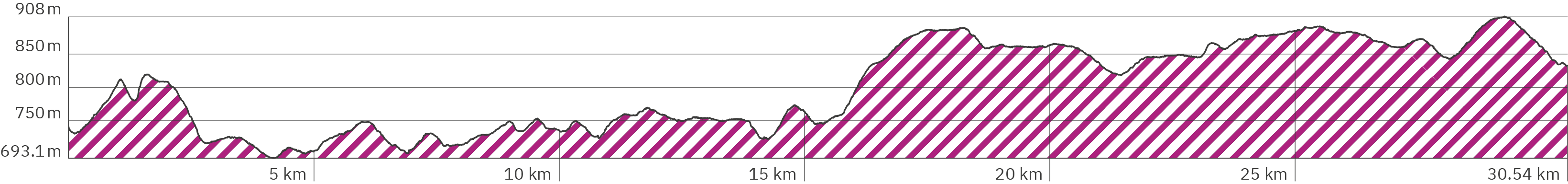
Length: approx. 30.5 km
Altitude: approx. 693m – 908m
Duration: approx. 10 hrs.
Peak travel season: May to September
Start: Großer / Kleiner Inselsberg
End: Rondell/Rennsteiggarten, Oberhof
Pano tour photos: Sep. & Oct. 2011
Ad

Elevation curve – Stage 2:
Interactive Panoramic Tour:
Legend – 360° Panoramic Tour

Main path forward

Main path backward

Detour forward

Detour backward

Explore forward

Explore backward
Legend – Map
Waypoint
Start / End
Detour
Explore
Point with extra info
Rest
Path type
Turnoff
Shelter
Accommodation
Camping
Public transport
Supermarket
View
Lavatory
Drinking water
ATM
Parking
Attention
Activity
Snack bar / Restaurant
The second Rennsteig stage leads – depending on where you stay – from the Großer or Kleiner Inselsberg through a lot of forest to Oberhof. After a few steep stretches at the beginning (both uphill and downhill), the path then leads steeply upwards for about 2 km in the second half – from an altitude of 750 meters to about 900 meters.
Level of difficulty:
Easy to medium – due to the length of the stage, physically challenging and demanding.
Accommodation at the start of the stage:
On top of Großer Inselsberg:
Berggasthof Stöhr – at the end of the stag, around km 33 (Google link also in pano), website berggasthof-stoehr.de
Herberge Großer Inselsberg (Google link also in pano), Website herberge-inselsberg.de
Alternative accommodation including an extra descent of roughly 30 minutes:
Hotel Kleiner Inselsberg (kink to Booking.com)*
Pension Rose am Reitstein (Google link also in pano), website haus-am-reitstein.de)
Important for the end of the stage in Oberhof and accommodation there:
The stage does not end in the village of Oberhof but roughly 2 km away from there. For the many accommodation options in Oberhof (link to Google Maps) you have to turn off 1 km before the end of the stage at the shelter Dietzel-Geba-Stein (Google link also in Pano) around km 29.6 – taking a left and walk from there roughly 2 km and 85 altimeter down to Oberhof (and a bit up again inside the town, depending on the guesthouse you choose). Or you go to the end of the stage at „Forstarbeiterdenkmal“ and to the bus stop Rondell/Rennsteiggarten Oberhof to take the bus 422 (timetable link of public transport website mbb-mgn.de) into town. Closest accomodation to the stage end is roughly 200 meters away A&S Ferienzentrum Oberhof (Booking.com link)*. On my first Rennsteig try I stayed over at Wagners Sporthotel Oberhof (Booking.com link)*. Back then I did not know that it would take so long to get to the hotel. Luckily, I did not have to wait for the bus for too long.
I stopped my first Rennsteig tour in Oberhof because I had chosen the wrong hiking shoes: heavy mountain boots with very hard soles They had brought me up on Mount Kilimanjaro but were completely unsuitable for the Rennsteig . As already mentioned on the introductory page of the Rennsteig, lighter shoes with softer soles are very useful here for covering the stages‘ many kilometers quickly. I’ve also written a blog article on this subject including my own experience and a presentation of the different hiking shoes I have used so far.
On my second attempt, I started with a different pair of shoes with the 3rd stage in the village – after an overnight stay in the pretty Hotel Vergissmeinnicht (Booking.com link)* which also offers a good restaurant for the evening.
Provisions:
This stage takes you steeply uphill for a longer time. In summer you should carry at least 2 liters of water with you – or fill up the supply regularly at the snack bars. Energy bars, fruit and sandwiches are always good. Yet, to get the real Rennsteig feeling should definitely add some breaks in the rustic restaurants or snack bars – but make sure in advance that they are open.
Snack bars, restaurants & accommodation on the way:
Berggasthof Heuberghaus – around km 4.2 (Booking.com link)*, (Google link), restaurant & holiday apartments, website heuberghaus.de
Grillimbiss Neue Ausspanne – around km 14.2 (Google link)
Bergwachthütten „Am Sperrhügel“ – around km 15.4 (Google link), apparently available to rent, snack bar of the mountain rescue Struth-Helmershof e.V. (no regular open hours – apparently marked by a hoisted flag), website bergrettung-struth.de
Gasthof „Thüringer Hütte“ – around km 28.2 (Google link), restaurant & grill, website thueringer-huette.de
Waldgasthof Schanzenbaude – around km 28.2 (Google link), restaurant & accommodation, website schanzenbaude.de
Shelters:
The second stage offers a lot 0f shelters / refuges. I haven’t stayed overnight in one myself. They are open, without doors and without a toilet. They are marked with the shelter icon on the map of the panorama tour. You can find some of them in Google Maps:
Rastplatz am Trockenberg – around km 1.1 (Google link)
Waltershäuser Hütte – Hut of the Alpine Club (not public) – around km 1.2 (Google link), (link to the Alpine Club)
Rastplatz Gabelwiese – around km 1.3 – Nicht verifiziert, weil nicht von mir besucht (Google link)
Schutzhütte am Jagdberg – around km 2.7 (Google link)
Possenröder Kreuz – around km 6.9 (Google link)
Dreiherrenstein – around km 9.9 (Google link)
Schützhütte an der Neuhöfer Wiese – around km 18.7 (Google link)
Schutzhütte Wachsenrasen – around km 21.4 (Google link)
Aussichtsturm Hoher Schorn – around km 21.5 (Google link)
R Schutzhütte am Dietzel-Geba-Stein – around km 29.6 (Google link)
Worth seeing:
Observation tower Aussichtsturm am Südlichen Spießerberg – around 6,5 (Google link) Apparently it was built after I did the tour
Vantage point Aussichtspunkt Spittergrund – around km 9,5 (Google link) Either I did not see it when I was there or it did not exist back then.
Spitterfall – waterfall I did not visit (Google link)
Löwen-Born – around km 10.2 (Google link) Well, not really spectacular but it is an old landmark from the 17th century.
Observation tower Aussichtsturm Kramerod – around km 14.5 (Google link), built after I did the tour.
Observation tower Aussichtsturm Hoher Schorn – around km 21.5 (Google link), built after I did the tour.
Forst worker monument Forstarbeiterdenkmal – around km 30 (Google link)
Rondell – around km 30.4 (Google link) at the end of the stage
Public transport / Getting there:
At the start of the stage you find at the foot of the Großer Inselsberg the bus stop Kleiner Inselsberg (Google link) for the buses 142 and 857 connecting the city of Eisenach and Bad Tabarz (link to the timetable of the public transport website vg-wartburgregion.de)
At the end of the stage you can take bus 422 to Oberhof. You can reach Oberhof by car or by bus also from the nearest town with a train station like Gotha.
On the way I came across several other bus stops:
Bus stop Nesselberg, Neue Ausspanne – around km 14.2 (Google link), Bus 851 (public transport link „Verkehrsverbund Mittelthüringen“)
Bus stop Grenzadler – around km 28.2 (Google link)
Bus stop Rondell/Rennsteiggarten – Oberhof – around km 30.5 (Google link), Bus 422 (timetable link of public transport website mbb-mgn.de)
Rennsteig – Stage 2 – Pano rsb-1
> Since I didn’t stay overnight on top of the Großer Inselsberg, I started the 2nd Rennsteig stage here
> Pension Rose am Reitstein (Google link), website haus-am-reitstein.de
> It starts on asphalt (follow the green arrows)
Rennsteig – Stage 2 – Pano rsb-2
> Cross the street and continue straight ahead
> Hotel Kleiner Inselsberg (Booking.com link also in pano)*
> Bus stop „Kleiner Inselsberg“ (Google link also in pano) – buses 142 and 857 (public transport link) connecting Eisenach und Bad Tabarz
Rennsteig – Stage 2 – Pano rsb-3
> Bench with backrest
> Parking Kleiner Inselsberg (Google link also in pano)
Rennsteig – Stage 2 – Pano rsb-4
> Turn right into the dirt road
> Continue on a level gravel path
Rennsteig – Stage 2 – Pano rsb-5
> Steeper and a little rocky uphill
Rennsteig – Stage 2 – Pano rsb-7
> Rest Rastplatz am Trockenberg (Google link also in pano), benches with backrests
Rennsteig – Stage 2 – Pano rsb-8
> Longer downhill
Rennsteig – stage 2 – rsb-9
> Waltershäuser Hütte – Alpine Club hut (not public) – around km 1,2 (Google link also in pano), (Link to Alpine Club)
Rennsteig – Stage 2 – Pano rsb-10
> Rest Rastplatz Gabelwiese – around km 1.3 – not verified / not visited by me (Google link also in pano)
Rennsteig – Stage 2 – Pano rsb-11
> Keep right at the fork
Rennsteig – Stage 2 – Pano rsb-12
> Steep uphill on stone steps
Rennsteig – Stage 2 – Pano rsb-13
> Continue steeply uphill on an uneven, stony path
Rennsteig – Stage 2 – Pano rsb-15
> shelter
> Rest area with table
> Turn left
> Level path downhill
Rennsteig – Stage 2 – Pano rsb-17
> Semi steep uphill
Rennsteig – Stage 2 – Pano rsb-18
> Keep left at the fork
Rennsteig – Stage 2 – Pano rsb-19
> Semi steep downhill
Rennsteig – Stage 2 – Pano rsb-22
> Shelter Schutzhütte am Jagdberg – around km 2.7 (Google link also in pano), to view it turn pano 180°
> Rest area with table
> Continue straight ahead
> Level path slightly downhill
Rennsteig – Stage 2 – Pano rsb-23
> Slightly uphill
Rennsteig – Stage 2 – Pano rsb-26
> Continue straight ahead
Rennsteig – Stage 2 – Pano rsb-27
> Semi left onto the forest path as an alternative to the concrete path
> Continue on soft ground interspersed with roots
Rennsteig – Stage 2 – Pano rsb-33
> Heuberghaus public car park
> Continue on asphalt
Rennsteig – Stage 2 – Pano rsb-34
> Cross the street straight ahead
Rennsteig – Stage 2 – Pano rsb-36
> Restaurant & accommodation Berggasthof Heuberghaus – around km 4.2 (Booking.com ink)*, (Google link)
Rennsteig – Stage 2 – Pano rsb-37
> Take the earthy forest path on the right, criss-crossed with roots, parallel to the asphalt road
> Hardly any incline
Rennsteig – Stage 2 – Pano rsb-43
> Turn right into the forest
> Slightly uphill
Rennsteig – Stage 2 – Pano rsb-44
> Continue straight ahead
Rennsteig – Stage 2 – Pano rsb-46
> Shelter
> Table and benches with backrest
Rennsteig – Stage 2 – Pano rsb-50
> Rest with a view, bench with backrest
> Apparently built after I did the tour: observation tower Aussichtsturm am Südlichen Spießerberg – around km 6.5 (Google link also in pano)
Rennsteig – Stage 2 – Pano rsb-51
> Keep on straight ahead
Rennsteig – Stage 2 – Pano rsb-53
> Turn left onto level gravel path
Rennsteig – Stage 2 – Pano rsb-54
> Shelter Possenröder Kreuz – around km 6.9 (Google link also in pano)
> Table with benches
> Turn right at the fork into the smaller level forest path – longer uphill from here
Rennsteig – Stage 2 – Pano rsb-66
> Not seen by me: observation tower Aussichtspunkt Spittergrund – around km 9.5 (Google link also in pano)
Rennsteig – Stage 2 – Pano rsb-68
> Dreiherrenstein – around km 9.9 (Google link also in pano)
> Table and benches with backrest
> Apparently there is an information hut or something similar that did not exist at the time of my hike.
> Turn left – slightly uphill
Rennsteig – Stage 2 – Pano rsb-70
> Continue straight ahead
> Here you could turn into the small path for an approx. 1 km long detour to the waterfall Spitterfall which I did not visit (Google link also in pano)
Rennsteig – Stage 2 – Pano rsb-71
> Löwen-Born – inconspicuous old landmark from the 17th century (Google link also in pano)
> Bench with backrest
> Continue to the right over the footbridge
> It goes steeply uphill on a soft nature trail with many roots
Rennsteig – Stage 2 – Pano rsb-73
> Cross the drivable path
> Continue on the narrow nature trail
> A little flatter
Rennsteig – Stage 2 – Pano rsb-74
> Turn right
> Continue on the wide, level gravel path
Rennsteig – Stage 2 – Pano rsb-75
> Turn left
> Rest at table on benches without backrests
Rennsteig – Stage 2 – Pano rsb-76
> Shelter
> Narrow table, benches without backrests
> Follow the path sharp to the left
> Long steep uphill on a wide gravel path
Rennsteig – Stage 2 – Pano rsb-79
> Continue straight ahead
Rennsteig – Stage 2 – Pano rsb-80
> Table with benches without backrest
> Turn right
Rennsteig – Stage 2 – Pano rsb-81
> Continue straight ahead
Rennsteig – Stage 2 – Pano rsb-82
> Continue to the right
Rennsteig – Stage 2 – Pano rsb-84
> Shelter
> Table, benches without backrest
> Continue straight ahead (path to the left of the shelter)
> Flatter, partly descending
Rennsteig – Stage 2 – Pano rsb-89
> Shelter
> Table, benches with backrest
> Continue straight ahead (on a wide gravel path)
> More descending
Rennsteig – Stage 2 – Pano rsb-91
> Parking „Neue Ausspanne“ (Google link also in pano)
> Benches without backrest
> Continue straight ahead
Rennsteig – Stage 2 – Pano rsb-92
> Grill and snack bar Grillimbiss Neue Ausspanne – around km 14.2 (Google link also in pano)
> Tables and benches with backrest
> Behind the snack bar straight ahead
Rennsteig – Stage 2 – Pano rsb-95
> Bus stop Nesselberg, Neue Ausspanne – around km 14.2 (Google link also in pano)
> Cross the country road
> Straight ahead on gravel path, first level than very steep
Rennsteig – Stage 2 – Pano rsb-99
> Bench without backrest
> Built after I did the tour: observation tower Aussichtsturm Kramerod – around km 14.5 (Google link also in pano)
Rennsteig – Stage 2 – Pano rsb-100
> Slightly downhill
Rennsteig – Stage 2 – Pano rsb-101
> Turn left onto the softer, narrow path
Rennsteig – Stage 2 – Pano rsb-102
> Continue to the right
Rennsteig – Stage 2 – Pano rsb-103
> Shelter
> Table and benches with backrest
> Continue left on the wide gravel path
> Not visited by me: mountain watch huts Bergwachthütten „Am Sperrhügel“ – around km 15.4 (Google link), maybe available to rent, snack bar of the moutain rescue Struth-Helmershof e.V. (open irregularly – apparently indicated by a hoisted flag) website bergrettung-struth.de
Rennsteig – Stage 2 – Pano rsb-104
> Straight ahead
> Not visited by me: mountain watch huts Bergwachthütten „Am Sperrhügel“ – around km 15.4 (Google link), maybe available to rent, snack bar of the moutain rescue Struth-Helmershof e.V. (open irregularly – apparently indicated by a hoisted flag) website bergrettung-struth.de
Rennsteig – Stage 2 – Pano rsb-105
> Continue straight ahead
> Steeper and a bit rocky
Rennsteig – Stage 2 – Pano rsb-106
> Continue to the left
Rennsteig – Stage 2 – Pano rsb-107
> Narrow table, benches with backrests
> It gets steeper
Rennsteig – Stage 2 – Pano rsb-111
> Shelter, table, benches with backrest
> Continue straight ahead, slightly uphill
Rennsteig – Stage 2 – Pano rsb-118
> Bench without backrest
Rennsteig – Stage 2 – Pano rsb-121
> Continue straight ahead
Rennsteig – Stage 2 – Pano rsb-122
> Shelter Schützhütte an der Neuhöfer Wiese – around km 18.7
(Google link also in pano – turn pano 90° left)
> Table, benches with backrest
Rennsteig – Stage 2 – Pano rsb-125
> Turn right on narrow path
> A bit steeper uphill
Rennsteig – Stage 2 – Pano rsb-128
> Turn semi right
Rennsteig – Stage 2 – Pano rsb-131
> Shelter Schutzhütte Wachsenrasen – around km 21.4 (Google link also in pano – turn pano 180°)
> Benches with backrests – today there are also tables apparently
> Continue straight ahead, turn right at the fork
Rennsteig – Stage 2 – Pano rsb-133
> Continue straight ahead
Rennsteig – Stage 2 – Pano rsb-134
> Benches with backrest and nice view
> Around here there should be the observation tower Aussichtsturm Hoher Schorn, which was built after I did the tour (Google link also in pano)
Rennsteig – Stage 2 – Pano rsb-137
> Turn right onto the uneven narrow path – gradually steeper uphill
Rennsteig – Stage 2 – Pano rsb-143
> Table and benches with backrest
Rennsteig – Stage 2 – Pano rsb-149
> Shelter
> Turn right (into 2nd path fro the right)
Rennsteig – Stage 2 – Pano rsb-152
> Bench with backrest
Rennsteig – Stage 2 – Pano rsb-156
> Turn left onto the gravel road
Rennsteig – Stage 2 – Pano rsb-157
> Left onto the narrow, soft nature trail
Rennsteig – Stage 2 – Pano rsb-161
> Continue on the flat gravel road
Rennsteig – Stage 2 – Pano rsb-164
> Roofed table and benches with backrest
> Continue straight ahead
Rennsteig – Stage 2 – Pano rsb-166
> Continue straight ahead
Rennsteig – Stage 2 – Pano rsb-167
> Roofed table and benches with backrests
> Continue straight ahead
Rennsteig – Stage 2 – Pano rsb-169
> Restaurant & grill Gasthof „Thüringer Hütte“ – around km 28.2 (Google link also in pano), website thueringer-huette.de
> Parking „Grenzadler“ (Google link also in pano)
> Keep on straight ahead
Rennsteig – Stage 2 – Pano rsb-170
> Bus stop Grenzadler – around km 28.2 (Google link also in Pano)
> Cross the country road, keep on straight ahead
Rennsteig – Stage 2 – Pano rsb-171
> Canopy with several tables and benches with backrest
> Stay left and keep straight on the natural trail
Rennsteig – Stage 2 – Pano rsb-172
> Restaurant & hotel Waldgasthof Schanzenbaude – around km 28.2 (Google link also in Pano), website schanzenbaude.de
> Turn left at second fork
> Steeper and more uneven
Rennsteig – Stage 2 – Pano rsb-175
> Continue straight ahead on the wide, level gravel path – it becomes flatter
Rennsteig – Stage 2 – Pano rsb-177
> Continue straight on drivable even gravel path, slightly uphill
Rennsteig – Stage 2 – Pano rsb-179
> Junction to Oberhof (turn left + approx. 1 km) follow the yellow arrow in the Pano (waypoints see below „+ waypoints – turn-off to Oberhof“)
> Or continue straight ahead for 1 km to the official stage end, from there by bus or on foot 2 km to Oberhof
> Shelter R Schutzhütte am Dietzel-Geba-Stein – around km 29.6 (Google link also in Pano – turn pano 180°)
> Benches with backrest
Rennsteig – Stage 2 – Pano rsb-185
> Forest workers‘ monument Forstarbeiterdenkmal (Google link also in pano)
> Straight ahead to the bridge
Rennsteig – Stage 2 – Pano rsb-186
> Monument Rondell (Google link also in pano)
Rennsteig – Stage 2 – Pano rsb-187
> End of the stage
> Bus stop Rondell/Rennsteiggarten Oberhof (Google link also in pano – turn pano 90° left), Bus 422 (timetable link to public transport website mbb-mgn.de)
> For hotels by foot or with a bus to Oberhof (approx. 2 km – one hotel approx. 150 meters away)
Rennsteig – stage 2 – detour to Oberhof – Pano rsb-188
> Stay right on the passable road (follow the yellow arrow)
Rennsteig – stage 2 – detour to Oberhof – Pano rsb-190
> Bench with backrest
Rennsteig – stage 2 – detour to Oberhof – Pano rsb-192
> Turn left
> Steep uphill
Rennsteig – stage 2 – detour to Oberhof – Pano rsb-193
> Straight ahead across the meadow
Rennsteig – stage 2 – detour to Oberhof – Pano rsb-194
> Continue straight ahead on gravel road
Rennsteig – stage 2 – detour to Oberhof – Pano rsb-195
> Turn left across the parking lot
> Continue on asphalt
Rennsteig – stage 2 – detour to Oberhof – Pano rsb-196
> Wagners Sporthotel Oberhof (Booking.com link)* – my stay during my first tour attempt (turn pano 90° right), Google Maps link, website sporthotel-oberhof.de
> After the parking lot, turn right into the larger street
Rennsteig – stage 2 – detour to Oberhof – Pano rsb-197
> Turn right into the main street
Rennsteig – stage 2 – detour to Oberhof – Pano rsb-199
> Turn left
Rennsteig – stage 2 – detour to Oberhof – Pano rsb-202
> End of the detour to Oberhof
> Hotel Vergissmeinnicht (Booking.com link)* – my stay at the start of my second tour attempt (link also in pano), Goole Maps link, website haus-vergissmeinnicht.de
> Link to pano tour start of stage 3 at the Rondell