Lion's Head
Hiking Trail: Lion’s Head
Continent: Africa
Region: Southern Africa
Countries: South Africa
Length: approx. 2 km (+ 2 km descent)
Altitude: approx. 286m – 599m
Duration: approx. 2.5 hrs. (+ 1 h. descent)
Peak travel season: October – March
Pano-Tour shot on 11 March 2011
Mit dem Laden der Karte akzeptierst Du die Datenschutzerklärung von Google.
By loading the map you agree to the privacy policy of Google.
Mehr erfahren / Learn more
Elevation Curve – Full Tour
Interactive Panoramic Tour: (Click the green arrow to follow the trail upwards)
Legend – 360° Panoramic Tour
Main path forward
Main path backward
Detour forward
Detour backward
Explore forward
Explore backward
Legend – Map
Waypoint
Start/Endpunkt
Detour
Explore
Wegpunkt mit Zusatzinfo
Rest
Snack bar / Restaurant
Attention
ATM
Parking
View
Dusche
Activity
Internetzugang
Lavatory
Public transport
Supermarket
Shelter
Camping
Accommodation
Weg- beschaffenheit
Drinking water
Turnoff
Brief Description
Lion's Head is a cone-shaped mountain, approximately 670 meters high and stands in front of Table Mountain. It offers a 360° panoramic view on Cape Town, Table Mountain, the Twelve Apostles, Camps Bay, Signal Hill and the sea. My recommendation: the very popular picnic at sunset followed by the rise of the full moon. More information on how to get there and the trail conditions are available in the location information of the virtual panoramic tour.
Preparation: An extra shirt as well as a sweater or fleece jacket are recommended. It can get very windy up there. Pack enough water (about 2 liters) and food - there is no possibility to refill on the way. When descending, the full moon offers some light, but a head light should definitely be carried with you.
Getting there: Drive from Cape Town to Camps Bay on Kloof Nek road, take the turn off at the signpost direction Signal Hill and then drive to the Lion's Head car park. At the time of the full moon you should arrive early, as parking spaces are limited. Security guards are often in place, but valuables should never be left in the car. All other items should be stowed in the trunk.
Hiking destination: A large platform with various seating options on the ground and on flat stones, and with magnificent panoramic views. Many people meet here for the full moon: after the sun sets in the sea, the full moon rises behind the sparkling city lights. At that time, the mountain is normally very crowded.
Descent: At full moon, the descent could be possible without a lamp – but you should definitely carry a lamp with you to be on the safe side. Especially after moonrise, there are traffic jams on the steep climbing passages. Therefore, the detour is the better option (indicated in the virtual tour by the yellow arrows for the ascent and the orange arrows for descending).
The tour points describe the way up.
Lion’s Head – Pano lh-1
> Start of the hike
> Smooth clay gravel path, approx. 25° gradient, slippery when wet
> Link to Google Maps in Pano
> Parking possibilities
Lion’s Head –Pano lh-4
> Resting place with a bench
Lion’s Head – Pano lh-5
> Resting place with a bench
Lion’s Head – Pano lh-9
> Activity (takeoff for paragliding)
Lion’s Head – Pano lh-10
> End of gravel road, start gravel path with long stretched but low steps
Lion’s Head – Pano lh-16
> More rocky with irratic and low natural steps
Lion’s Head – Pano lh-20
> Resting place on rock
> Less clay, rather flat stone path
Lion’s Head – Pano lh-21
> Resting place with a bench
> Path with big flat stones
Lion’s Head – Pano lh-24
> Resting place on rocks
> Beautiful view over Signal Hill
Lion’s Head – Pano lh-26
> Steep with big natural stone steps
Lion’s Head – Pano lh-29
> Resting place on several big rocks with a beautiful view over Signal Hill
Lion’s Head – Pano lh-32
> Very slippery iron ladder! about 2 meters high
Lion’s Head – Pano lh-33
> Narrow part with high stone steps
Lion’s Head – Pano lh-34
> High stone step with iron handle, 15 meters long narrow part with a chain to hold on to
Lion’s Head – Pano lh-35
> Narrow part with a chain to hold on to
Lion’s Head – Pano lh-36
> Narrow flat stone path
Lion’s Head – Pano lh-37
> Varying stone steps
Lion’s Head – Pano lh-41
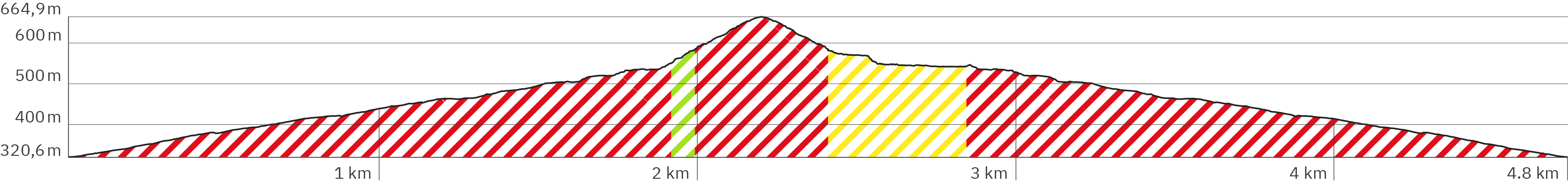
> Turnoff – the green arrow follows the regular path with a high difficulty level (including a steep passage where you have to pull yourself up on chains); the yellow arrow offers a detour around it which takes a little longer.
Lion’s Head – Pano lh-42
> Very high and narrow step
Lion’s Head – Pano lh-43
> Start of the climb with handles and chains
Lion’s Head – Pano lh-44
> Very steep climb with handles and chains to pull yourself up
Lion’s Head – Pano lh-45
> Very steep climb with handles and chains
Lion’s Head – Pano lh-46
> End of the climb with handles and chains
Lion’s Head –Pano lh-48
> High stone steps
Lion’s Head – Pano lh-52
> Turnoff – here the detour around the steep climb passage meets the regular path again. (The orange arrows follow the detour path downwards.)
Lion’s Head – Pano lh-54
> Attention: The roots on the path are very slippery
Lion’s Head –Pano lh-57
> Steep ascent with high steps
Lion’s Head – Pano lh-58
> Very high stone with very small step
Lion’s Head – Pano lh-59
> Very slippery iron ladder, about 2 meters high
Lion’s Head – Pano lh-65
> Varying high stone steps and steps fixed with wood
Lion’s Head – Pano lh-72
> End of tour: Spacious plateau and various resting places on all sides to enjoy the view
Lion’s Head – Pano lh-73
> View on the Twelve Apostles and Camps Bay
Lion’s Head – Pano lh-74
> View over Clifton and of the sunset
Lion’s Head – Pano lh-75
> View over Clifton, Sea Point and of the sunset
Lion’s Head – Pano lh-76
> Blick über Sea Point und auf den Sonnenuntergang
Lion’s Head – Pano lh-76
> View over Sea Point and of the sunset
Lion’s Head – Pano lh-77
> View over Signall Hill, Green Point and of the sunset
Lion’s Head – Pano lh-78
> View over Cape Town and of the full moon rise
Lion’s Head – Pano lh-79
> View over Cape Town, on Table Mountain and of the full moon rise
Lion’s Head – Pano lh-81
> View on Table Mountain and the Twelve Apostles
The tour points describe the way up.
Lion’s Head – Pano lh-97
> Resting place on stone with an overhanging rock for a bit of shelter
Lion’s Head – Pano lh-94
> Very narrow path
Lion’s Head – Pano lh-91
> Very narrow stone steps
Lion’s Head – Pano lh-90
> Very high steps fixed with slippery wood
Lion’s Head – Pano lh-89
> More even part but with tricky stones
Lion’s Head – Pano lh-84
> High and narrow stone steps
*The links that are marked with an asterisk are affiliate links. The help to finance this site's production by advertisements. (After every link you'll find the respective brand to which the link leads you to.) With every click you help that this hiking website can stay alive and regularly offers new virtual panoramic tours of popular hiking trails. The same counts for the advertising banners, which are chosen as relevantly as possible for hikers and travelers.