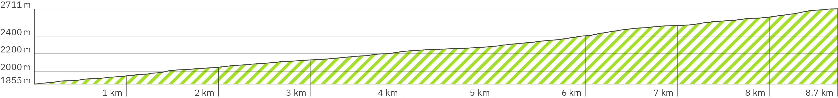
Kilimanjaro – Marangu Route – Stage 1 – Pano kja-1
> Start – at the KINAPA headquarters, the official organization is TANAPA , Tanzania National Parks (links in also pano)
> The paid entry to the Kilimanjaro National Park should be registered early through a local organization. A guide and the appointment of porters is mandatory.
> Follow the blue arrow to the toilet, the green arrow for the tour
Kilimanjaro – Marangu Route – Stage 1 – Pano kja-3
> Memorial plaque about the first ascent of Kilimanjaro as well as important information and rules
> Turn left on tar road slightly uphill
Kilimanjaro – Marangu Route – Stage 1 – Pano kja-5
> Entrance to the national park
> Stony clay soil slightly uphill
Kilimanjaro – Marangu Route – Stage 1 – Pano kja-7
> Steep uphill with stairs made of big stones
> With a little more shade through the forest
Kilimanjaro – Marangu Route – Stage 1 – Pano kja-8
> Slightly stony clay path, more uphill
Kilimanjaro – Marangu Route – Stage 1 – Pano kja-10
> Fewer stones, slightly downhill
Kilimanjaro – Marangu Route – Stage 1 – Pano kja-12
> Clearing without shade
> Stronger uphill again with more stones
Kilimanjaro – Marangu Route – Stage 1 – Pano kja-15
> A little more shade
> Less rocky, level clay path slightly uphill
Kilimanjaro – Marangu Route – Stage 1 – Pano kja-17
> Wooden bridge over a streambed
Kilimanjaro – Marangu Route – Stage 1 – Pano kja-25
> Milestone
Kilimanjaro – Marangu Route – Stage 1 – Pano kja-28
> Steep uphill over slippery roots and large stones
Kilimanjaro – Marangu Route – Stage 1 – Pano kja-29
> Under large branches
> A little more level again, steeply uphill
Kilimanjaro – Marangu Route – Stage 1 – Pano kja-31
> Less steep uphill
> Sporadic roots and stones
Kilimanjaro – Marangu Route – Stage 1 – Pano kja-35
> A little more uphill
> More stones and slippery roots
Kilimanjaro – Marangu Route – Stage 1 – Pano kja-47
> Children present a chameleon on a stick and ask for money for this little attraction
Kilimanjaro – Marangu Route – Stage 1 – Pano kja-49
> More uphill with more rocks and slippery roots through denser forest with more shade
Kilimanjaro – Marangu Route – Stage 1 – Pano kja-59
> Less steep uphill
Kilimanjaro – Marangu Route – Stage 1 – Pano kja-60
> Through bushes, on larger rocks across a small quiet stream
Kilimanjaro – Marangu Route – Stage 1 – Pano kja-61
> After a short part slightly downhill a little more uphill again over slippery roots and isolated stones
Kilimanjaro – Marangu Route – Stage 1 – Pano kja-63
> Turn right over the wooden bridge
> Milestone
Kilimanjaro – Marangu Route – Stage 1 – Pano kja-64
> Wooden bridge over a small rushing stream
> Continue slightly uphill, few stones and roots
Kilimanjaro – Marangu Route – Stage 1 – Pano kja-68
> Flat path with few stones, alternating slightly uphill and downhill
Kilimanjaro – Marangu Route – Stage 1 – Pano kja-72
> A little rockier, more uphill
Kilimanjaro – Marangu Route – Stage 1 – Pano kja-75
> Turnoff to the rest area with toilet at access road – follow blue arrow over wooden bridge
Kilimanjaro – Marangu Route – Stage 1 – Pano kja-76
> Rest area with narrow tables and benches without backrest
> The road is not permitted for hikers
> Follow blue arrow to the toilet
> Follow purple arrow back to path
Kilimanjaro – Marangu Route – Stage 1 – Pano kja-77
> Toilets
Kilimanjaro – Marangu Route – Stage 1 – Pano kja-78
> Flat clay path with gravel, stronger uphill
Kilimanjaro – Marangu Route – Stage 1 – Pano kja-79
> Occasional slippery roots
> Partly downhill
Kilimanjaro – Marangu Route – Stage 1 – Pano kja-81
> A little more uphill
Kilimanjaro – Marangu Route – Stage 1 – Pano kja-84
> Steeper uphill, higher root and rock steps
Kilimanjaro – Marangu Route – Stage 1 – Pano kja-85
> Only a few stones, slightly steep uphill
Kilimanjaro – Marangu Route – Stage 1 – Pano kja-87
> Less steep uphill again
Kilimanjaro – Marangu Route – Stage 1 – Pano kja-88
> Uneven with larger stones and roots
Kilimanjaro – Marangu Route – Stage 1 – Pano kja-95
> A bit more level again, further uphill
Kilimanjaro – Marangu Route – Stage 1 – Pano kja-95
> Again very uneven, natural stairs over larger roots and stones
Kilimanjaro – Marangu Route – Stage 1 – Pano kja-98
> Flatter again, less rocky, slightly uphill
Kilimanjaro – Marangu Route – Stage 1 – Pano kja-101
> More uphill, uneven, natural stairs over larger stones and slippery roots
Kilimanjaro – Marangu Route – Stage 1 – Pano kja-106
> Flatter again, fewer stones and roots, less steep uphill
Kilimanjaro – Marangu Route – Stage 1 – Pano kja-109
> After a wooden bridge on a very unevenly paved stone path, it climbs more strongly uphill
> Milestone
Kilimanjaro – Marangu Route – Stage 1 – Pano kja-110
> Again very uneven on clay, lots of slippery roots, steeper uphill
Kilimanjaro – Marangu Route – Stage 1 – Pano kja-112
> Slightly leveler and less steep
Kilimanjaro – Marangu Route – Stage 1 – Pano kja-114
> Uneven over slippery roots and wooden beams, steeper uphill
Kilimanjaro – Marangu Route – Stage 1 – Pano kja-117
> More uneven, slightly less steep uphill
Kilimanjaro – Marangu Route – Stage 1 – Pano kja-122
> Leveler, slightly uphill, the forest thins out
Kilimanjaro – Marangu Route – Stage 1 – Pano kja-126
> Uneven with lots of stones in the clay, steeper uphill, more shade again in dense forest
Kilimanjaro – Marangu Route – Stage 1 – Pano kja-130
> Large old trees line the path
Kilimanjaro – Marangu Route – Stage 1 – Pano kja-132
> Further uphill with rows of stones as steps
Kilimanjaro – Marangu Route – Stage 1 – Pano kja-133
> More level, less steep uphill, a little more light
> Enchanted, bush-like, dense tree growth with thin trunks
Kilimanjaro – Marangu Route – Stage 1 – Pano kja-145
> Stretched steps with wooden edges, a little steeper uphill, more dense tree growth and more shade
Kilimanjaro – Marangu Route – Stage 1 – Pano kja-150
> Just slightly uphill, the forest becomes thinner again
Kilimanjaro – Marangu Route – Stage 1 – Pano kja-152
> Again more shade
Kilimanjaro – Marangu Route – Stage 1 – Pano kja-154
> Short steeper climb up to the huts to arrive
Kilimanjaro – Marangu Route – Stage 1 – Pano kja-159
> End of the 1st stage at the Mandara Huts (Google link also in pano)
> Starting point for a short hike to the Maundi Crater and the 2nd stage (links also in pano)
{https://hikingtrailview.com/de/rennsteig-virtuelle-360-panoramatour/kilimandscharo-kilimanjaro-Marangu-Route-etappe-stage-2/}
{https://hikingtrailview.com/de/rennsteig-virtuelle-360-panoramatour/kilimandscharo-kilimanjaro-Marangu-Route-Maundi-Crater}
> Follow blue arrows to have a look around
kja-155
> Large communal hut, to eat together at long tables
> Numerous small huts for 4 people each
kja-156
> Entrance to an overnight hut
> There is probably a large building now
kja-157
> Inside a sleeping hut
kja-158
> Toilets and showers