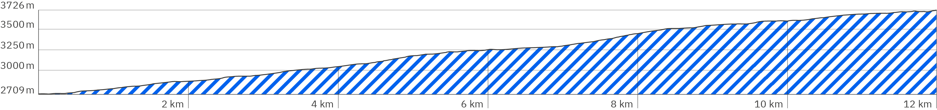
Kilimanjaro – Marangu Route – Stage 2 – Pano kjb-1
> Start of the 2nd stage, follow the green arrows
> Also end of the 1st stage {https://hikingtrailview.com/de/rennsteig-virtuelle-360-panoramatour/kilimandscharo-kilimanjaro-Marangu-Route-etappe-stage-1/} at the Mandara Huts and start of the excursion to Maundi Crater {https://hikingtrailview.com/de/rennsteig-virtuelle-360-panoramatour/kilimandscharo-kilimanjaro-Marangu-Route-Maundi-Crater} (links also in pano)
Kilimanjaro – Marangu Route – Stage 2 – Pano kjb-2
> Slightly uphill on a flat clay path, partly shady
Kilimanjaro – Marangu Route – Stage 2 – Pano kjb-6
> More shadow
Kilimanjaro – Marangu Route – Stage 2 – Pano kjb-8
> After a short wooden bridge over a stream bed, rocky and uneven, less shade
Kilimanjaro – Marangu Route – Stage 2 – Pano kjb-9
> Turn off to Maundi Crater {https://hikingtrailview.com/de/rennsteig-virtuelle-360-panoramatour/kilimandscharo-kilimanjaro-Marangu-Route-Maundi-Crater}, continue to the left for the main path
Kilimanjaro – Marangu Route – Stage 2 – Pano kjb-10
> Level, sometimes small steps
Kilimanjaro – Marangu Route – Stage 2 – Pano kjb-11
> Cross a small wooden bridge into the forest, it becomes shady for a short while
Kilimanjaro – Marangu Route – Stage 2 – Pano kjb-13
> After a short wooden bridge, rocky, uneven and without shade, steeply uphill
Kilimanjaro – Marangu Route – Stage 2 – Pano kjb-15
> Less steep and more level
Kilimanjaro – Marangu Route – Stage 2 – Pano kjb-17
> Alternation between shade and sun
Kilimanjaro – Marangu Route – Stage 2 – Pano kjb-18
> Uneven and rocky, no shade, slightly steeper uphill
Kilimanjaro – Marangu Route – Stage 2 – Pano kjb-21
> Very uneven and rocky, steep uphill
Kilimanjaro – Marangu Route – Stage 2 – Pano kjb-22
> Flat and slightly downhill, no shade
Kilimanjaro – Marangu Route – Stage 2 – Pano kjb-23
> Uneven and rocky, steeper uphill
Kilimanjaro – Marangu Route – Stage 2 – Pano kjb-24
> Uneven and rocky, slightly uphill
Kilimanjaro – Marangu Route – Stage 2 – Pano kjb-25
> Very uneven and rocky, more uphill
Kilimanjaro – Marangu Route – Stage 2 – Pano kjb-28
> Even, slightly uphill
Kilimanjaro – Marangu Route – Stage 2 – Pano kjb-30
> Stronger uphill
Kilimanjaro – Marangu Route – Stage 2 – Pano kjb-32
> Even, sometimes small steps with wooden edges, less steep uphill
Kilimanjaro – Marangu Route – Stage 2 – Pano kjb-33
> Very uneven, coarse stone paving, steeper uphill
Kilimanjaro – Marangu Route – Stage 2 – Pano kjb-34
> More level and less steep uphill
Kilimanjaro – Marangu Route – Stage 2 – Pano kjb-37
> Stronger uphill
Kilimanjaro – Marangu Route – Stage 2 – Pano kjb-38
> A little flatter uphill
Kilimanjaro – Marangu Route – Stage 2 – Pano kjb-39
> Uneven and rocky, steeper uphill
Kilimanjaro – Marangu Route – Stage 2 – Pano kjb-43
> Slightly uphill
Kilimanjaro – Marangu Route – Stage 2 – Pano kjb-44
> Rocky and uneven, steeply uphill
Kilimanjaro – Marangu Route – Stage 2 – Pano kjb-45
> Even and steeper downhill
Kilimanjaro – Marangu Route – Stage 2 – Pano kjb-46
> Level and slightly uphill
Kilimanjaro – Marangu Route – Stage 2 – Pano kjb-47
> Very uneven with large stones, steeper uphill
> A porter with a heavy box on his head
Kilimanjaro – Marangu Route – Stage 2 – Pano kjb-48
> Level and slightly downhill
Kilimanjaro – Marangu Route – Stage 2 – Pano kjb-49
> Uneven, steeper uphill
Kilimanjaro – Marangu Route – Stage 2 – Pano kjb-50
> Less steep uphill
Kilimanjaro – Marangu Route – Stage 2 – Pano kjb-53
> More even
Kilimanjaro – Marangu Route – Stage 2 – Pano kjb-54
> Short wooden bridge
Kilimanjaro – Marangu Route – Stage 2 – Pano kjb-55
> Very uneven with large stones, more uphill
Kilimanjaro – Marangu Route – Stage 2 – Pano kjb-57
> Here you can see how muddy the path can become when it is wet: your shoes sink a few centimeters into the ground, making progress very difficult, and the big number of hikers softens the path even more
Kilimanjaro – Marangu Route – Stage 2 – Pano kjb-61
> Rest area with narrow tables and benches without backrests
> Follow the blue arrow to the toilet
Kilimanjaro – Marangu Route – Stage 2 – Pano kjb-62
> Toilet
Kilimanjaro – Marangu Route – Stage 2 – Pano kjb-63
> Soft clay path, uneven, crisscrossed by larger stones, steeper uphill
Kilimanjaro – Marangu Route – Stage 2 – Pano kjb-67
> Uneven, roughly paved with stones, steeper uphill
Kilimanjaro – Marangu Route – Stage 2 – Pano kjb-68
> More even, fewer stones, less steep uphill
Kilimanjaro – Marangu Route – Stage 2 – Pano kjb-69
> Stronger downhill
Kilimanjaro – Marangu Route – Stage 2 – Pano kjb-70
> Uneven, coarse gravel and larger stones, more uphill
Kilimanjaro – Marangu Route – Stage 2 – Pano kjb-71
> More even, less steep uphill
Kilimanjaro – Marangu Route – Stage 2 – Pano kjb-75
> Shortly steeper downhill, after a short wooden bridge very uneven with larger stones, steeper uphill
Kilimanjaro – Marangu Route – Stage 2 – Pano kjb-76
> A little more even, interrupted by larger stones, more uphill
Kilimanjaro – Marangu Route – Stage 2 – Pano kjb-77
> After a long, slight downhill section, more uphill again, even and fewer stones
Kilimanjaro – Marangu Route – Stage 2 – Pano kjb-78
> After a very uneven downhill section over a short wooden bridge, then steeper uphill, uneven and more stones
Kilimanjaro – Marangu Route – Stage 2 – Pano kjb-79
> Shortly downhill, then slightly uphill, a bit uneven
Kilimanjaro – Marangu Route – Stage 2 – Pano kjb-80
> Very uneven, roughly paved with large stones, steeper uphill
Kilimanjaro – Marangu Route – Stage 2 – Pano kjb-81
> Steep uphill, very uneven at times with scree and large stones
Kilimanjaro – Marangu Route – Stage 2 – Pano kjb-83
> Less uphill and more even
Kilimanjaro – Marangu Route – Stage 2 – Pano kjb-84
> Uneven with very large stones, more uphill
Kilimanjaro – Marangu Route – Stage 2 – Pano kjb-85
> Shortly flatter and over a short wooden bridge
Kilimanjaro – Marangu Route – Stage 2 – Pano kjb-86
> A bit more even with fewer stones, stronger uphill
Kilimanjaro – Marangu Route – Stage 2 – Pano kjb-90
> More downhill, a bit rockier
Kilimanjaro – Marangu Route – Stage 2 – Pano kjb-92
> Short wooden brigde over a small stream, where examples of the endemic giant groundsel, Dendrosenecio Kilimanjari, grow
> Before destination another short, steep and rocky uphill climb
Kilimanjaro – Marangu Route – Stage 2 – Pano kjb-93
> Steep and rocky upwards on pebble gravel
Kilimanjaro – Marangu Route – Stage 2 – Pano kjb-95
> End of the 2nd stage at the Horombo Huts
> To look around, follow the blue arrows
> Links to the acclimatization hike to the Zebra Rocks {https://hikingtrailview.com/de/rennsteig-virtuelle-360-panoramatour/kilimandscharo-kilimanjaro-Marangu-Route-Zebra-Rocks} and to the 3rd stage in the Pano {https://hikingtrailview.com/de/rennsteig-virtuelle-360-panoramatour/kilimandscharo-kilimanjaro-Marangu-Route-etappe-stage-3/}