Rennsteig - Stage 4 - Neustadt am Rennsteig – Limbach
Trail records – Stage 4:
Hiking Trail: Rennsteig
Stage: 4. Neustadt am Rennsteig – Limbach
Continent: Europe
Region: Central Europe
Countries: Germany
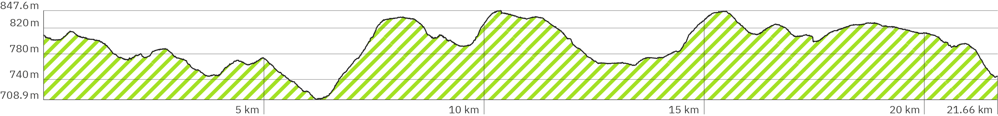
Length: approx. 21.7 km
Altitude: approx. 709m – 848m
Duration: approx. 8 Std.
Peak travel season: May to September
Start: Neustadt am Rennsteig (Großbreitenbach)
End: Limbach
Pano tour photos: Sep. & Oct. 2011
Ad

Elevation curve – Stage 4:
Interactive Panoramic Tour:
Legend – 360° Panoramic Tour

Main path forward

Main path backward

Detour forward

Detour backward

Explore forward

Explore backward
Legend – Map
Waypoint
Start / End
Detour
Explore
Point with extra info
Rest
Path type
Turnoff
Shelter
Accommodation
Camping
Public transport
Supermarket
View
Lavatory
Drinking water
ATM
Parking
Attention
Activity
Snack bar / Restaurant
The 4th Rennsteig stage leads from Neustadt am Rennsteig (Großhöhenbach) to Limbach. It starts slightly uphill on the sidewalk through Neustadt. On the way there is a supermarket on the way and a gas station at the end of the village, to stock up on your provisions. There aren’t too many restaurants along the hiking trail. The path leads again mostly through forest with short bright spots over fields. There are longer sections alongside country roads, longer sections on gravel paths but also longer sections on soft, sometimes muddy and narrow paths. Ascents (412 m in total) and descents 476 m somwhat balance each other out. Numerous benches with backrests invite you to take a rest, mostly in the shade of the forest, but some also on the edge of the forest with wider views and in the sun.
Level of difficulty:
Easy to medium – due to a greater number of ups and downs of the stage still physically challenging and demanding.
Snack bars, restaurants & accommodation:
Supermarket Nahkauf – around km 0.1 (Google link also in pano)
Gas station with shop: Q1 Tankstelle – around km 0.6 (Google link also in pano)
Restaurant / Snack bar Gasthaus Trinitusbaude – around km 6.5 (Google link also in pano)
Restaurant „Turmbaude am Rennsteig“ – around km 10.4 (Google link also in pano), includes a terrace with beer benches
Restaurant & accommodation Gasthaus & Pension „Zum Rennsteig“ – around km 16.9
(Google link also in pano) website rennsteig.de/gasthaus-pension-zum-rennsteig
Restaurant & accommodation Gaststätte & Pension „Hirschblick“ – around km 16.9 mit Abzweigung durch Friedrichshöhe (Google link also in pano) website hirschblick.de
Shelters:
On the 4th stage there are fewer shelters. And some of them are so small that they are rather a shelter against rain than a place to sleep. In some of them tables and benches take a way lots of space. But it has been so many years since my hike that some of them must have been modernized. If you have new information, please send me a message so that I can include it here.
Shelter with grill / fireplace Grillplatz & Schutzhütte – around km 1.1 (Google link also in pano)
Shelter at the parking & rest Schwalbenhaupt – around km 6.4 (Google link also in pano)
Very small shelter with table and benches – around km 6.5
Shelter full with table and benches – around km 7.7
Shelter „Heidehütte“ – around km 11.5 (Google link also in pano)
Shelter „Eisfelder Ausspanne“ – around km 13.5 (Google link also in pano)
Shelter at the landmark Dreistromstein – around km 19.3 (Google link also in pano)
Schutzhütte at the start of the destination village Limbach – around km 21.5
Worth seeing:
Geodetic reference point Geodätischer Referenzpunkt – around km 9.5 (Google link also in pano)
Observation tower Aussichtsturm „Rennsteigwarte Masserberg“ – around km 10.4 (Google link also in pano)
Landmark Dreistromstein – around km 19.3 (Google link also in pano)
Public transport:
At the start of the stage: Bus stop Neustadt am Rennsteig, Kaufhalle – around km 0.1 (Google link also in Pano), buses 209 & 304 public transport website iov-ilmenau.de
Bus stop Kahlert – around km 1.7 (Google link also in pano), buses 209 & 304 public transport website iov-ilmenau.de
Bus stop Masserberg, Abzweig Katzhütte – around km 6.4
(Google link also in pano), buses 203, 206, 209, 508 public transport websites taxi-ilchmann.de & bus-bahn-thueringen.de
Bus stops Masserberg – around km 9.5 (Google link also in pano) buses 203, 206, 207, 209 and bus 508 (public transport websites)
Bus stop Friedrichshöhe b. Eisfeld (Google link), bus 508 (public transport website) – around km 16.9 but with detour through Friedrichshöhe
Accommodation at the start in Neustadt am Rennsteig:
There are several accommodation options (Booking.com-Link)* which you can also see in the following Google Maps link for the hotel I used. On my tour I stayed at the Hotel-Gasthof Hubertus (Google link also pano), website rennsteighotel-hubertus.de.
Accommodation at the end of the stage in Limbach:
Apparently there is only one guesthouse directly at the trail in Limbach which I therefore chose: the Rennsteig-Pension „Trautwein“ (Google link also in pano), website rennsteig-pension-trautwein.de.
According to Google there is an alternative approx. 350 meters further north in the village of Alsbach: Pension Alsbachberg (Google link also in pano), website thueringen.info/alsbachberg.
Guesthouses along the trail:
Hotel Haus Oberland – around km 9.6 (Google link also in pano), website hotel-haus-oberland.de
Two possible guesthouses in Friedrichshöhe (Eisfeld) (Google link also in pano) – around km 16.9 but including a detour through the village:
– Gasthaus & Pension „Zum Rennsteig“ (Google link also in pano), website rennsteig.de/gasthaus-pension-zum-rennsteig
– Gaststätte und Pension „Hirschblick“ (Google link also in pano), website hirschblick.de
Rennsteig – Stage 4 – Pano rsd-1
> Start of the 4th Stage in Neustadt am Rennsteig
> The guesthouse I chose on my tour: Hotel-Gasthof-Hubertus (Google link also in pano), website rennsteighotel-hubertus.de
> Other options see Google link for the hotel above / in pano or Booking.com link*
> Also the end of the 3rd stage – link also in pano
> It starts slightly uphill on the pavement along the road through town
Rennsteig – Stage 4 – Pano rsd-3
> At the roundabout keep right
> Between this and the next pano:
– Supermarket Nahkauf (Google link also in pano)
– Bus stop Neustadt am Rennsteig, Kaufhalle (Google link also in pano), bus 209 & 304, public transport website iov-ilmenau.de
Rennsteig – Stage 4 – Pano rsd-6
> A bit steeper uphill
Rennsteig – Stage 4 – Pano rsd-7
> Change to the left side of the road
> Further on a narrow dirt path alongside the country road
> Possible shop for provisions: gas station Q1 Tankstelle (Google link also in pano)
> Hikers‘ parking Wanderparkplatz on the other side of the road (Google link also in pano)
Rennsteig – Stage 4 – Pano rsd-9
> Shelter and grill / fireplace Grillplatz & Schutzhütte (Google link also in pano)
> Continue straight ahead, slightly downhill
Rennsteig – Stage 4 – Pano rsd-11
> Slightly steeper downhill, very narrow path through undergrowth
Rennsteig – Stage 4 – Pano rsd-12
> Very narrow table with very narrow benches
Rennsteig – Stage 4 – Pano rsd-13
> A kind of Christian open-air church
Rennsteig – Stage 4 – Pano rsd-15
> Continue along the country road
Rennsteig – Stage 4 – Pano rsd-16
> Turn right, cross the country road and the traffic refuge into the village of Kahlert
> Bus stop Kahlert (Google link also in pno) buses 209 & 304 (public transport website ivo-ilmenau.de), with small shelter
> Table and benches with backrest
> Continue flat on asphalt
Rennsteig – Stage 4 – Pano rsd-17
> Turn left
> Slightly uphill
Rennsteig – Stage 4 – Pano rsd-19
> Semi right further on a narrow forest path
> Short downhill, then steeper uphill
Rennsteig – Stage 4 – Pano rsd-21
> Rougher narrow path criss-crossed with roots
Rennsteig – Stage 4 – Pano rsd-23
> A chair with a backrest
Rennsteig – Stage 4 – Pano rsd-24
> Slightly downhill
Rennsteig – Stage 4 – Pano rsd-26
> Cross the street, continue left along the road
> A dirt track on lawn, only slightly uphill
Rennsteig – Stage 4 – Pano rsd-27
> A bit uneven narrow forest path, slightly downhill
Rennsteig – Stage – Pano rsd-29
> Slightly uphill
Rennsteig – Stage 4 – rsd-30
> Narrow table and bench with backrest
> Continue straight ahead, slightly downhill, narrow lawn trail
Rennsteig – Stage 4 – Pano rsd-32
> Flat, over the boardwalk
Rennsteig – Stage 4 – Pano rsd-33
> Narrow table and benches with backrest
> Slightly steeper uphill, narrow gravel path
Rennsteig – Stage 4 – Pano rsd-35
> Table and benches with backrest
> Continue straight ahead, slightly downhill, soft forest path
Rennsteig – Stage 4 – Pano rsd-36
> More uphill, alongside the country road
Rennsteig – Stage 4 – Pano rsd-38
> Slightly downhill, a little rougher with roots
Rennsteig – Stage 4 – Pano rsd-40
> Continue following the path semi left
Rennsteig – Stage 4 – Pano rsd-41
> Table and bench with backrest
> Dirt track across an open lawn, slightly downhill
Rennsteig – Stage 4 – Pano rsd-43
> Slightly steeper downhill, uneven forest path
Rennsteig – Stage 4 – Pano rsd-44
> Continue straight ahead, slightly uphill
Rennsteig – Stage 4 – Pano rsd-45
> Shelter at the parking & rest Schwalbenhaupt (Google link also in pano)
> Table and benches with backrests under a small roof
> Straight ahead, slightly downhill across the gravel parking lot
Rennsteig – Stage 4 – Pano rsd-46
> At the end of the parking lot, turn right and cross the country road
> Bus stop Masserberg, Abzweig Katzhütte (Google link also in pano), buses 203, 206, 209, 508 – public transport websites taxi-ilchmann.de & bus-bahn-thueringen.de
Rennsteig – Stage 4 – Pano rsd-47
> Even drivable gravel path
Rennsteig – Stage 4 – Pano rsd-48
> Restaurant / snack bar Gasthaus Trinitusbaude (Google link also in pano)
> Slightly uphill
Rennsteig – Stage 4 – Pano rsd-49
> Small sheltered rest hut with table and benches
> Table and benches with backrest under a small roof
> Turn left into the forest path
Rennsteig – Stage 4 – Pano rsd-50
> Slightly steeper uphill, very bumpy, rocky, interspersed with roots and with very soft spots
Rennsteig – Stage 4 – Pano rsd-52
> Continue straight ahead, cross the road
Rennsteig – Stage 4 – Pano rsd-53
> Narrower, very uneven, soft, interspersed with roots, a bit steeper uphill
Rennsteig – Stage 4 – Pano rsd-57
> The path only briefly becomes wider, flatter and more even
Rennsteig – Stage 4 – Pano rsd-58
> Again narrow, steeper and rocky
Rennsteig – Stage 4 – Pano rsd-60
> Short stair section, fixed with boards
Rennsteig – Stage 4 – Pano rsd-63
> Shelter, full of table and benches
> Narrow bench outside without backrest
> Turn left, slightly uphill, slightly wider gravel path, partly overgrown with grass
Rennsteig – Stage 4 – Pano rsd-66
> Continue straight ahead
Rennsteig – Stage 4 – Pano rsd-67
> Keep right at the fork
> Slightly uphill
Rennsteig – Stage 4 – Pano rsd-68
> Mini table and bench
Rennsteig – Stage 4 – Pano rsd-69
> Continue on a passable stone/gravel road
> Slightly downhill
Rennsteig – Stage 4 – Pano rsd-70
> Slightly uphill
Rennsteig – Stage 4 – Pano rsd-71
> A bit more downhill
Rennsteig – Stage 4 – Pano rsd-72
> Continue straight ahead
Rennsteig – Stage 4 – Pano rsd-73
> Stay left on the wide path
> Slightly uphill
Rennsteig – Stage 4 – Pano rsd-74
> Slightly downhill
Rennsteig – Stage 4 – Pano rsd-75
> Open field bench with back rest and wider view
Rennsteig – Stage 4 – Pano rsd-76
> Comfortable bench in the shade with backrest and wide view
Rennsteig – Stage 4 – Pano rsd-77
> Continue straight ahead
Rennsteig – Stage 4 – Pano rsd-78
> Parking Rennsteig Masserberg (Google link also in pano) with lavatories
> Wider gravel path, slightly downhill
Rennsteig – Stage 4 – Pano rsd-79
> Geodetic reference point Geodätischer Referenzpunkt (Google link also in pano)
> Bus stop Masserberg (Google link also in pano), buses 203,206,207, 209 (bus-bahn-thueringen.de), bus 508 (taxi-ilchmann.de)
> Seating with backrest
> Continue straight ahead, flatter on gravel path
Rennsteig – Stage 4 – Pano rsd-80
> Hotel Haus Oberland (Google link also in pano), website hotel-haus-oberland.de
> Turn right, slightly uphill on asphalt
Rennsteig – Stage 4 – Pano rsd-81
> Continue straight ahead
Rennsteig – Stage 4 – Pano rsd-82
> Table and benches with backrests under a small roof
> Continue straight ahead on a wide gravel path, slightly uphill
Rennsteig – Stage 4 – Pano rsd-84
> Table and benches with backrest
Rennsteig – Stage 4 – Pano rsd-86
> Follow blue arrow to the entrance of the „Turmbaude am Rennsteig“
Rennsteig – Stage 4 – Pano rsd-88
> Restaurant „Turmbaude am Rennsteig“ (Google link also in pano)
> Lavatory
> Terrace with beer benches
Rennsteig – Stage 4 – Pano rsd-87
> Observation tower Aussichtsturm „Rennsteigwarte Masserberg“ (Google link also in pano)
Rennsteig – Stage 4 – Pano rsd-89
> Flat, very slightly uphill, continue on a wide level passabel gravel path
Rennsteig – Stage 4 – Pano rsd-90
> Table and benches with backrest
Rennsteig – Stage 4 – Pano rsd-91
> Turn semi left at the fork
> Slightly narrow gravel path
Rennsteig – Stage 4 – Pano rsd-93
> Bench with backrest
Rennsteig – Stage 4 – Pano rsd-95
> Bench with backrest
Rennsteig – Stage 4 – Pano rsd-96
> Bench with backrest
> Slightly downhill
Rennsteig – Stage 4 – Pano rsd-97
> Shelter „Heidehütte“ (Google link also in pano)
> Table and benches with backrest
> Turn semi right into narrow forest path
> Earthier, rockier and more downhill
Rennsteig – Stage 4 – Pano rsd-105
> Very small shelter
> Table and benches with backrest
> Keep left, continue on the forest path
Rennsteig – Stage 4 – Pano rsd-107
> Loamy with muddy sections
Rennsteig – Stage 4 – Pano rsd-108
> Continue straight ahead, more uphill
Rennsteig – Stage 4 – Pano rsd-110
> Turn left
> Continue on earthy forest path, slightly downhill
> Table and benches with backrest
Rennsteig – Stage 4 – Pano rsd-111
> Cross the wide gravel path
> Shelter „Eisfelder Ausspanne“ (Google link also in pano)
> Tables and benches with backrest
> Continue to the right of the shelter, slightly uphill, very narrow, somewhat rocky forest path
Rennsteig – Stage 4 – Pano rsd-113
> Semi left on a wide, passable gravel road
Rennsteig – Stage 4 – Pano rsd-114
> Turn semi left onto narrow, soft, uneven forest path
Rennsteig – Stage 4 – Pano rsd-119
> Rough, rocky with more roots, slightly steeper uphill
Rennsteig – Stage 4 – Pano rsd-121
> Table and benches with backrest
> Only slightly uphill
Rennsteig – Stage 4 – Pano rsd-124
> Narrow bench with backrest
Rennsteig – Stage 4 – Pano rsd-126
> A bit wider path, firmer, slightly overgrown with grass
Rennsteig – Stage 4 – Pano rsd-127
> Continue left on the narrow forest path, slightly downhill
Rennsteig – Stage 4 – Pano rsd-130
> Semi left on the wide, passable gravel road
Rennsteig – Stage 4 – Pano rsd-131
> Turn semi left into the narrow forest path
Rennsteig – Stage 4 – Pano rsd-133
> Continue on the path next to the gravel road
Rennsteig – Stage 4 – Pano rsd-135
> Keep left, continue on the wide, passable gravel road
Rennsteig – Stage 4 – Pano rsd-136
> Narrow table and benches under a small roof
> Continue the hiking trail to the left (bypassing the village) on a narrow gravel path
> Possible turnoff through Friedrichshöhe (Eisfeld) with restaurant, accommodation, and bus – keep right (Google link also in pano)
> Restaurant & guesthouse Gasthaus & Pension „Zum Rennsteig“ (Google link), website rennsteig.de/gasthaus-pension-zum-rennsteig
> Restaurant & guesthouse Gaststätte & Pension „Hirschblick“ (Google-Link), website hirschblick.de
> Holiday aparment Bleßbergblick (Google-Link), website blessbergblick.de
> Holiday house Arnika (Google-Link), website ferienhaus-arnika.de
> Bus stop Friedrichshöhe b. Eisfeld (Google link), bus 508 (public transport website)
Rennsteig – Stage 4 – Pano rsd-139
> Bench with backrest and view over the field
Rennsteig – Stage 4 – Pano rsd-140
> Bench with backrest and view over the field
> Continue straight ahead, slightly downhill
Rennsteig – Stage 4 – Pano rsd-141
> Bench with backrest and view over the field
Rennsteig – Stage 4 – Pano rsd-144
> Parking lot
Rennsteig – Stage 4 – Pano rsd-145
> Uneven forest path, roots, slightly uphill, in some places with mud puddles
Rennsteig – Stage 4 – Pano rsd-147
> Table and benches with backrest
Rennsteig – Stage 4 – Pano rsd-150
> Table and bench with backrest
> Semi left on a wide level gravel path
Rennsteig – Stage 4 – Pano rsd-151
> Shelter at the Dreistromstein (Google link also in pano – turn pano 180°)
> Table and benches with backrest
> Narrow forest path, slightly uphill
Rennsteig – Stage 4 – Pano rsd-154
> Continue straight ahead
Rennsteig – Stage 4 – Pano rsd-155
> Natural path over short hills
Rennsteig – Stage 4 – Pano rsd-158
> Continue straight ahead, slightly downhill
> Bench with backrest, next to it very small canopy
Rennsteig – Stage 4 – Pano rsd-159
> Bench with backrest
> Flat uneven dirt road
Rennsteig – Stage 4 – Pano rsd-160
> Mini table and seating group carved from logs
> Dirt road, slightly steeper downhill
Rennsteig – Stage 4 – Pano rsd-161
> Bench with backrest and view over the field
Rennsteig – Stage 4 – Pano rsd-163
> Slightly uneven, narrow forest path, further downhill
Rennsteig – Stage 4 – Pano rsd-164
> Shelter at village entrance to Limbach, the stage’s destination
> Table and benches with backrest
> Continue semi right, downhill on a wide gravel path
Rennsteig – Stage 4 – Pano rsd-166
> Attention when crossing the country road
> Continue straight ahead, slightly uphill
Rennsteig – Stage 4 – Pano rsd-167
> End of the 4th stage
> Follow blue arrow to view the accommodation I chose
> Green arrow to the start link for the 5th stage
Rennsteig – Stage 4 – Pano rsd-169
> My accommodation at the end of the stage in the town Limbach: Rennsteig-Pension „Trautwein“ (Google link also in pano), website rennsteig-pension-trautwein.de
Rennsteig – Stage 4 – Pano rsd-168
> Link for the 5th stage also in pano
Ad